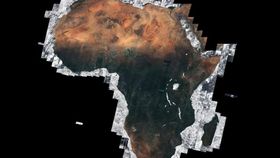


The Sentinel-2A satellite has been hard at work some 786 kilometers (488 miles) above Africa. Using thousands of its images, the European Space Agency has created a beautiful mosaic showing a cloudless view of the whole African continent.
Taken largely over a period between December 2015 and April 2016, the Sentinel-2A collected nearly 7,000 images of the continent, an area that accounts for around 20 percent of the world’s land.
The Sentinel-2A’s multispectral camera is able to sweep across and record in 290-kilometer (180-mile) wide swaths, capable of analyzing around 290,000 square kilometers (112,000 square miles) – an area larger than the United Kingdom – in 4 minutes, the BBC reports.
Overall, the images for this one mosaic contain a massive 32 terabytes of data – that’s over 1,000 Blu-Ray discs worth of images.
Best of all, all the work done by this floating mass of high-tech equipment is open-source and free to use. The data it collects can be used for a whole manner of practical purposes, from detailing changes in landscapes to monitoring pollution, and even agricultural or urban planning.
Sentinel-2A is set to have its “identical twin,” the Sentinel-2B, launched by 2017 in order to amass even more incredible imagery and mind-blowing quantities of data.
Head over to the European Space Agency website for more information and a hi-res version of the image.

Image credit: Copernicus Sentinel data (2016), processed by Brockmann Consult/ Université catholique de Louvain as part of ESA’s Climate Change Initiative Land Cover project