

NASA has confirmed that New Orleans and the surrounding areas are sinking at a much higher rate than previously thought. Using airborne radar to map the rate at which the ground is sinking over a period of a few years, they were able to document in fine detail exactly which regions are most at risk, and where planning and building needs to be monitored.
The Earth’s surface can sink due to a mixture of natural and man-made causes. The weight of deposited sediment can, for example, cause subsidence, as can the movement of glaciers and the compaction of shallow sediments. But humans can also influence this process by pumping out oil and gas, or in the example of New Orleans, by the withdrawal of water.
The extraction of groundwater and dewatering of the region, in which surface water is removed in order to prevent standing water or saturated earth, is causing the city to sink. This has been exasperated by the building of levees, which prevent the natural build-up of sediment that counteract the sinking.

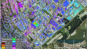
The region of Norco is one of the worst affected, sinking 5 centimeters (2 inches) per year. NASA/JPL-Caltech, Esri
This is most acute in regions upriver along the Mississippi River, specifically the industrial areas of Norco and Michoud, where the ground is sinking by a worrying 5 centimeters (2 inches) per year. Other areas of concern were in New Orleans Upper and Lower 9th Ward, where the subsidence may be related to the water levels of the Mississippi. Of particular concern is the changes in ground level around the levees built to prevent flooding, as they found regions behind the levees sinking by 4 centimeters (1.6 inches) a year.
The data used by NASA to build the maps, published in a paper in the Journal of Geophysical Research, was created using NASA’s Uninhabited Aerial Vehicle Synthetic Aperture Radar (UAVSAR), which is able to track changes in elevation on the Earth’s surface down to a centimeter difference. This by itself can’t tell the researchers what is causing the change in ground level, so they then have to disentangle all the possible causes, which operate at different time and space scales.
While the fact that the region is sinking is not new, NASA have highlighted that the degree to which it is happening is much greater than previously thought, and that it could be putting certain regions at a much greater risk of flooding, as if there wasn’t a big enough one to begin with. It is hoped that the data can be used to attempt to reduce or reverse the subsidence in the most severely affected areas, as well as help with planning decisions for the future.