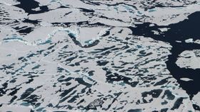
2016 has been a record-breaking year in terms of global warming, from the hottest month ever to the hottest entire year on record. Arctic sea levels have also been breaking a few of their own records, with March hitting a record low of maximum sea ice extent and May experiencing rapid ice melt several weeks ahead of schedule.
The good news is by June the rapid ice melt had slowed down, thus ending the record-smashing roll of the first half of the year. The bad news is that even though this summer may not break any new records, what would have been considered an alarmingly extreme rate of global warming just 10 years ago is, according to NASA, the “new normal”, and accepting that is very sobering.
“Even when it’s likely that we won’t have a record low, the sea ice is not showing any kind of recovery. It’s still in a continued decline over the long term,” said Walt Meier, a sea ice scientist at NASA’s Goddard Space Flight Center in a statement.
“A decade ago, this year’s sea ice extent would have set a new record low and by a fair amount. Now, we’re kind of used to these low levels of sea ice – it’s the new normal,” Meier added.
Having accepted this, scientists at NASA are now looking for a way to better measure and track the shifting Arctic sea levels by preparing a new method for measuring the thickness of the sea ice – a good indication of how fast it’s melting – from space.

Research ships and submarines are currently used to track the thickness directly, but a far more accurate and efficient method would be to use satellites that can take readings using radar, much like those already being used to monitor sea temperatures. Unfortunately, something is getting in the way of the radar being able to read the sea ice thickness: salt in the water of the melting ice.
In response, scientists led by Thorsten Markus, chief of Goddard’s cryosphere lab, are launching the Ice, Cloud and land Elevation Satellite-2 (ICESat-2), which will use lasers to get a more complete picture of the Arctic sea ice.
Scheduled to launch in 2018, ICESat-2 will use a laser altimeter to measure the heights of Earth’s surface, where it will measure the elevation of the ice floes in the Arctic, compared to the water level. Taking into consideration only one-tenth of sea ice is above water, NASA can then calculate the thickness of the ice from the distance measured by the satellite.
From this, we may not be able to stop the rising sea levels in the Arctic from being the “new normal”, but we will have a better understanding of what to expect and how to deal with it.
"If we want to estimate mass changes of sea ice, or increased melting, we need the sea ice thickness," Markus explained. "It’s critically important to understanding the changes in the Arctic."
NASA Goddard's Scientific Visualization Studio/Cindy Starr