

In a stunning world first, scientists have used drones to create a 3D model of a volcano using its thermal signature. Although thermal imaging of volcanoes isn’t new, this complex, groundbreaking method to map one of the world’s most active volcanoes is nothing but novel – and the results are resplendent, a portrait of one of nature’s most spectacular hellish forges.
Professor John Howell, a geologist from the University of Aberdeen and lead researcher on the project, opined that if this drone-based method could be automated, then it “could really revolutionize how we monitor volcanoes,” describing it as a potential “game-changer for the people who live and work in their shadow.”
Stromboli, one of the Aeolian Islands north of Sicily, is one of the most awe-inspiring places on Earth, a place where, every few hours or so, you can see fire fountains of lava shoot skyward and illuminate the night sky. It’s dubbed the “Lighthouse of the Mediterranean,” and it’s entirely unsurprising that it proved to be the inspiration for Tolkien’s Mount Doom.
Far from just being an aesthetically pleasing sight, it’s also a laboratory for volcanologists. It’s fire fountains and lava bombs, falling down on the Sciara del Fuoco (“stream of fire”) slopes leading down to the island’s black sand beaches, provides researchers with an excess of data to analyze.
It even has an eponymous eruption style. As the magma rises up through the volcano’s throat and depressurizes, gas exsolves from it and bubbles form. If the magma is gloopy (viscous) enough, these bubbles join up to form a gas slug, which forces a chunk of magma out of the vent, often as a tall fire fountain.
All of this activity gives off heat, which can be picked up by specialized equipment. Indeed, volcanoes around the world are monitored on or near the ground, and by satellite, in terms of their thermal emissions, which can be used to track the movement of magma, lava, and hydrothermal fluids through the system.

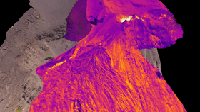
What the team from the Universities of Aberdeen and Oslo wanted, however, was something far more ambitious. They wanted to model Stromboli’s heat output at a far higher resolution, so they could accurately model when, where and how its magmatic innards changed in any way.

Remote sensing and distant instrumentation just wouldn’t cut it. Instead, they attached thermal imaging equipment to drones, and flew them right up to the volcano. Using drones to take detailed photographic images of the edifice too, they overlaid both data sets to create the world’s first 3D thermal model of a volcano.
This is a proof-of-concept, low-cost design, one that the team hope will ultimately lead to an autonomous network of drones that continuously monitor the volcano – but already, at this early stage, the model is proving its worth. It’s clearly precise enough to detect heat changes in the volcano, which would reveal when magma’s ascending through the conduit.
Although it’s fun to venture into the belly of the beast, fieldwork around active volcanoes can be dangerous and potentially fatal. Drones circumvent this problem, and although Stromboli is infrequently a hazardous volcano to be around, this system could genuinely help to save lives around other, more enigmatic fiery mountains around the world.
This isn’t the first time drones have been used to peer inside volcanoes, mind you.
From Guatemala’s Volcán de Fuego to Vanuatu’s Ambrym, collapsing lava domes to tempestuous lava lakes have recently been documented by the flying robots in unprecedented ways – and science is better off as a result.
As this new research so neatly reminds us, the future won’t be delivered on foot, but by remote control.