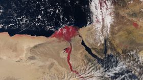


It might look like a scene from a Bible story, but this image showing Egypt's River Nile glowing a deep blood red is actually the result of imaging techniques used to monitor Earth’s environmental health.
The rest of this article is behind a paywall. Please sign in or subscribe to access the full content.This recently released satellite image was taken by the European Space Agency’s (ESA) Sentinel-3A satellite on March 3. Along with the River Nile, shown as a red strip in the center, you can also see Cyprus to the north, the Greek island of Crete in the top left corner, and the Red Sea just east of the Nile. Using the onboard instruments to measure levels of energy radiating from Earth’s surface and color data, the red color in the image shows the presence of vegetation around the Nile.
This state-of-the-art satellite was only launched on February 16 and is already beaming back data about Earth’s oceans, land, ice, and atmosphere. Along with providing real-time data on weather forecasts, the information will be used to provide sturdy details on environmental changes.
The Associated Press reports that ESA has described its new set of eyes in the sky as the “most sophisticated Earth observation system ever launched.” One of its most impressive skills is the ability to scan the entire Earth in just one day, then transmit the data back to Earth within a few hours.
Visit the ESA website for a downloadable high-res version of the image, along with more information on the image and the Sentinel-3A satellite .