


The Colorado River Basin provides water to 40 million Americans and 4 million acres of farmland in seven western states. Unfortunately, recent analysis has revealed that over the last nine years, the groundwater from the basin is disappearing much more quickly than was predicted. The collaborative study was led by Jay Famiglietti of Jet Propulsion Laboratory and the paper was published in Geophysical Research Letters.
Information regarding the amount of water lost was collected via NASA’s Gravity Recovery and Climate Experiment (GRACE) satellite between December 2004 and November 2013. The data suggests that droughts have contributed to a loss of 64.8 km3 of freshwater. Disturbingly, over 75% of that loss appears to have come from groundwater sources, meaning it is getting depleted at an unprecedented and alarming rate.
"We don't know exactly how much groundwater we have left, so we don't know when we're going to run out," lead author Stephanie Castle said in a press release. "This is a lot of water to lose. We thought that the picture could be pretty bad, but this was shocking.”
Unfortunately, a lack of consistent record keeping has made tracking water levels difficult. Water levels above ground are regulated at the federal level by the U.S. Bureau of Reclamation and are well-documented. Groundwater sources are managed at the state level, and there are not uniform policies in place and the records are not complete.
"There's only one way to put together a very large-area study like this, and that is with satellites," Famiglietti explained. "There's just not enough information available from well data to put together a consistent, basin-wide picture.”
GRACE is able to track the differences in groundwater volumes based on changes in mass, which slightly alters the gravitational attraction in that region. These numbers were compared with the Bureau of Reclamation’s data on above ground water sources, allowing the researchers to determine the fluctuation of groundwater volume over time.
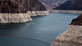
”The Colorado River Basin is the water lifeline of the western United States," said Famiglietti. "With Lake Mead at its lowest level ever, we wanted to explore whether the basin, like most other regions around the world, was relying on groundwater to make up for the limited surface-water supply. We found a surprisingly high and long-term reliance on groundwater to bridge the gap between supply and demand.”
Lake Mead is the largest reservoir in the region and set a record last month for the lowest water level since it was filled in 1937. Increasing scarcity of resources could lead to massive revisions of water allocation as soon as April 2016.
"Combined with declining snowpack and population growth, this will likely threaten the long-term ability of the basin to meet its water allocation commitments to the seven basin states and to Mexico," Famiglietti said.


