For the first time, meteorologists have observed persistent drizzle under conditions where snow would be expected. Besides identifying a phenomena weather watchers never anticipated, the discovery could lead to a tweaking of climate models, making them that little bit more accurate.
We expect a simple division of conditions – rain when temperatures are above freezing, snow when they're below. Hail complicates things, but only because ground level is warmer than the clouds in which it forms. Freezing drizzle is the reverse, falling as rain before turning to dangerous black ice on hitting the ground, but this usually only happens at temperatures a little below zero.
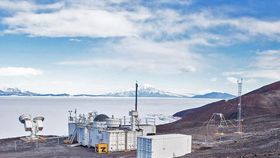
Yet at McMurdo Station, Antarctica, a team reported persistent drizzle, the kind that leads people from sunnier climates to mock the residents of Manchester, Seattle, or Melbourne. This happened with temperatures as low as -25ºC (-13º F) in the clouds from which the water came. When they say persistent, they mean it – the tiny droplets didn't let up for 7.5 hours.
To most of us, drizzle is just annoying misty rain, but meteorologists define it as rain droplets smaller than 0.5 millimeters (0.002 inches) across.
"We're familiar with drizzle as a process that takes place in warm temperatures," Dr Israel Silber of Penn State University said in a statement. "At lower temperatures, processes like ice formation and growth make the probability for drizzle production significantly lower."
Although supercooled drizzle had been reported before, incidents were relatively brief until August 2016. A combination of lasers and ground-based devices confirmed that what the station was experiencing was indeed very small spherical drops of water, despite the freezing temperatures. Satellites showed the drizzle was probably occurring across some 1,000 kilometers (600 miles) of the Ross Ice Shelf.
Climate models treat liquid precipitation (be it rain or drizzle) the same way, and don't allow for either to occur under very cold conditions. Silber says that needs to change.
"Drizzle should be properly simulated in models because it removes water from the cloud layer when droplets combine with one another and eventually fall," Silber said. Drizzle movement through the cloud is faster than ice crystals. "That means drizzle would affect the cloud's lifetime, which would influence the amount of heat reaching the Earth's surface."
Silber and colleagues have discussed this in the Journal of Geophysical Research: Atmospheres, but what most of the world probably wants to know is how it's possible. The answer is supercooling, where water can remaining liquid well below freezing point if it lacks a site of nucleation for ice crystals to form around.
In clouds, these nuclei are provided by aerosols, but Silber noted: “In Antarctica the air is very clean. There are fewer pollutants, and therefore fewer airborne particles.”