

A newly announced technique will allow marine scientists to measure the acid/base balance of remote parts of Earth's oceans without needing to visit hard-to-reach regions or deploy floats. The satellite measurements will allow researchers to track the lesser known aspects of burning fossil fuels on ocean acidification.
The Earth's oceans are slightly basic, with a pH of around 8.1 on a scale of 0 to 14, with lower numbers as acidic, higher numbers as basic, and 7 as neutral. This pH level is vital to many marine species that need a basic environment in which to build their shells and skeletons. However, when carbon dioxide is dissolved in water, it produces a weak acid, which reduces the number of CO32− bicarbonate ions and makes it harder for some species to survive. Other creatures experience more subtle effects.
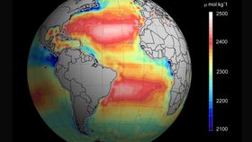
With a quarter of the carbon dioxide released from burning fossil fuels being absorbed by the oceans, its acidity has risen 26% since the start of the industrial revolution, while carbonate ions have fallen 16%. However, tracking the scale of this problem has been a challenge. The pH of the ocean varies as a result of factors such as river flows and plant uptake of carbon. While we have a reasonably good database of changes occurring close to shore, the open ocean is a different matter.
In Environmental Science and Technology, an international team announced that salinity, temperature and color data collected by satellites can be adapted to calculate the pH of the ocean at a particular point.
Ocean color is important because it can be used to measure the quantity of chlorophyll-a in phytoplankton. Since 2009, satellites have been tracking surface salinity through the microwave radiation emitted by surface waters. Combining these two measurements with surface temperature data provides the ingredients to calculate acid concentrations, the authors maintain.
“Routine measurements from space can provide quasi-synoptic, reproducible data for investigating processes on global scales,” the authors argue. “They may also be the most efficient way to monitor the ocean surface.”
Satellite measurements have weaknesses, the paper acknowledges. Salinity measurements in particular “can be affected by nearby land or sea ice, and the sensitivity decreases for cold water.” Nevertheless, first author Dr. Peter Land of Plymouth Marine Laboratory argues, "In recent years, great advances have been made in the global provision of satellite and in situ data. It is now time to evaluate how to make the most of these new data sources to help us monitor ocean acidification, and to establish where satellite data can make the best contribution."
Since satellites can only indicate the temperature and salinity at the very top of the ocean, researchers will continue to rely on floats to learn what is occurring at depth. Moreover, the limitations of the spaceborne instruments mean that for the foreseeable future, floats and research vehicles will be considerably more accurate. Nevertheless, the authors hope satellite data will fill in gaps in our knowledge of ocean acidification, particularly in the sensitive polar oceans and the Bay of Bengal.