

A NASA and NOAA satellite has returned its first images of lightning in clouds on Earth, which could prove vital in monitoring severe storms and protecting against natural disasters.
The rest of this article is behind a paywall. Please sign in or subscribe to access the full content.The GOES-R satellite (Geostationary Operational Environmental Satellite), also called GOES-16, was launched on November 19, 2016. It is the 16th satellite in the GOES series of Earth observation satellites, of which only several are still operational. In January this year, it returned its first stunning images of Earth.
GOES-16 is in a geostationary orbit 35,000 kilometers (22,000 miles) above Earth, where it is using a suite of instruments to monitor storms and weather on Earth. One of these is the Geostationary Lightning Mapper (GLM), the first lightning detector flown in geostationary orbit.
Positioned above the Americas, the satellite can track lightning in clouds continuously to a resolution of about 10 kilometers (6 miles). While quite large, this is enough to see the near-infrared and optical flashes produced by lightning, allowing the satellite to map where lightning is occurring.
“Rapid increases of lightning are a signal that a storm is strengthening quickly and could produce severe weather,” NASA noted in a statement. “During heavy rain, GLM data will show when thunderstorms are stalled or if they are gathering strength.”
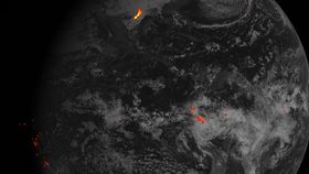
A storm over the Gulf of Texas
The data was gathered on February 14 this year, using an astonishing 1.8 million images of Earth to produce one hour of lightning mapping. The image you can see above and below uses the lightning data overlaid on an image of Earth taken by the satellite’s Advanced Baseline Imager (ABI).
In the full image below, color bar units correspond to kilowatt-hours of total optical emissions from lightning. In this data, the brightest storm is located over the Gulf Coast of Texas. The brighter colors indicate areas where more lightning data was gathered.
According to NASA, this data will help forecasters identify areas that are prone to wildfires sparked by lightning. It could also help anticipate severe weather, including flash floods, in dry areas like the western United States.
Tracking lightning and thunderstorms will also help planes and ships navigate around them more easily. Interestingly, the GLM can also detect in-cloud lightning, which occurs five to 10 minutes before ground strikes.
There will be plenty more awesome imagery and data from GOES-16 to look forward to in the future, and there will be three more GOES satellites – dubbed S, T, and U – that will help NOAA and NASA monitor Earth from geostationary orbit up until 2036.

The full image of the lightning map data. The color bar units on the right correspond to kilowatt-hours of total optical emissions from lightning. NOAA/NASA