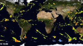


When lost for words, many of us resort to talking about the weather. But now if a conversation lulls, you will have something truly interesting to say: A video of near real-time global estimates of rain and snow over the last six months was released yesterday by NASA’s Global Precipitation Measurement (GPM) mission. The visualization was created from snapshots taken every 30 minutes by a dozen weather-monitoring satellites.
“This is a great dataset that has recently been delivered by the Global Precipitation Measurement team,” said Gail Skofronick-Jackson, a GPM project scientist at NASA. “It shows that we are able to measure both the regional scale and the global scales of precipitation at a very fine temporal resolution.”
The collection of satellites provide a high-resolution image of about 10- by 10-kilometers (6.2 miles) and spans nearly the entire planet—from 60 degrees north to 60 degrees south latitude.
Satellite imagery usually measures cloud tops and temperature, but this mission can “look under the clouds and see what the precipitation is doing,” said George Huffman, the deputy project scientist for GPM, to The Washington Post. “This is a new effort, and is considerably more difficult than the cloud maps.”
The GPM satellite network also provides precise details of precipitation in three dimensions. For example, the video below shows the winter storm that swept across Kentucky, West Virginia and North Carolina on February 17.
This storm-monitoring capability is not the only benefit of the technology. According to Live Science, the dataset will also help scientists better understand how carbon dioxide, ocean winds, and aerosol particles behave on a global scale.