

If you live on the Eastern Seaboard, it’s likely you noticed that it’s been a bit chilly recently – snowstorm levels of chilly, anyway. If you’re wondering where it came from, you can blame Canada, whose cold air is spilling into the country and bringing a bit of Narnia to the US.
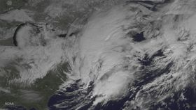
NASA, not one to shy away from showing off their photography skills, decided to snap a photograph of winter storm Niko as it blanketed a good chunk of America this week. This time, the agency used its GOES East weather satellite, which is jointly run along with the National Oceanic and Atmospheric Administration (NOAA).
From a height of 35,800 kilometers (22,300 miles) above the surface of the planet, it’s difficult to tell that a whopping 46 centimeters (18 inches) of snow landed in New England. However, the scale of this chilly beast is plain to see, and at the time of writing, the snow’s still falling.
So wrap up warm, Americans – and watch out for any White Walkers.
[H/T: Space]