Although climate change is bad news for the whole of our planet, some areas of the world are better equipped to cope with the stresses and strains it will bring.
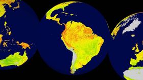
In a recent study published in Nature, a team of biologist and ecologists created a map that displays the areas of Earth’s vegetation most vulnerable to climate change.
The information was gathered through satellite data taken between 2000 and 2013. The study measured what they call the “vegetation sensitivity index.” This was calculated by comparing the “vegetation productivity” of an area with three climate variables: water availability, air temperature, and cloud cover. This was done for every 5-square-kilometer (1.9-square-mile) patch of land. How strongly these three factors disturbed the vegetation productivity was used as an assessment of how sensitive the ecosystem’s vegetation is.

The map displays the globe's vegetation sensitivity. Image credit: Seddon et al./Nature
The index gauges sensitivity levels from 0 to 100, with 0 being the least sensitive. On the map, low sensitivity is represented in green, medium in orange, and high sensitivity in red. Wetland areas are shown in blue, and areas deemed permanently ice-covered or barren, such as the Sahara Desert and Antarctica, were left grey.
The overall map appears as a pale yellow-green, suggesting that the majority of the world’s plant life is moderately to well prepared for climate change. However, as the authors described, there are some very ecologically sensitive areas, including the Arctic tundra, tropical rainforests, and alpine regions worldwide.
The authors aim to add to this already expansive study over the following years. By continuing to gather data, they hope to establish if these changes in vegetation are simply blips or a long-lasting trend.
[H/T: Popular Science]