

Kilauea’s not making headlines like it used to, and this is somewhat understandable. Apart from the occasional footage of a “volcanic tornado”, it’s not changing its rhythm at present: lava continues to ooze from Fissure 8, fine glassy fragments of “Pele’s hair” are still raining down around the fissure’s seaward lava channel, and acidic laze plumes continue to rise up from the sea.
The rest of this article is behind a paywall. Please sign in or subscribe to access the full content.This may be the new normal, but Hawaii hasn’t run out of magmatic magic tricks just yet. Kilauea just demonstrated this rather beautifully by not only creating a new island offshore, but by taking it away again just hours later.
So what is it, and where did it come from – and where did it go?
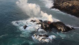
Photographs from July 13-14 revealed that the island, still oozing fresh lava, had been spotted by the United States Geological Survey (USGS) on the northern end of the current lava entry point around Kapoho Bay. Although it’s not clear what size it is from the aerial photographs, it’s safe to say that it is, or rather was, incredibly small.
It’s worth emphasizing that this isn’t a new volcanic island forming in the way that you might think.
In places around the world – and indeed, in the Hawaiian archipelago – rapid, persistent, voluminous effusions of lava from the seafloor can rise up into the sky and form a new island. As with the new delta forming in Kapoho Bay, the land survives if the rate of geological creation outpaces the rate of marine erosion.

Kilauea – fueled by a rising, superheated mantle plume creating plenty of melting in the overlying crust – may be the center of volcanism on Big Island at present, but a new seamount, an underwater volcano, is forming offshore. Named Loihi, it will one day become the new center as the Pacific Plate drifts atop the stationary plume.
In 10,000 to 100,000 years, Loihi will rise up above the waves and become the new, dominant land volcano. That is not what this new, currently unnamed island is.
According to the USGS, it’s a feature of the lava flow from Fissure 8. Some details are missing – no-one actually saw it emerge, after all – but here are a few possibilities as to what may have happened in this case.
As of July 13, lava from the 6-kilometer (3.7-mile) flow front along Kapoho Bay was continuing to flow. A small island then appeared just offshore from its northern edge, which was created in one of two ways.
One possibility is that the lava was part of the delta, and the bridge to the land broke away, leaving a lump of land. Alternatively, lava just tumbled into the sea – either from the visible shoreline or from a lava tube beneath the waves – and built up on the very shallow coastal shelf to form an island.
On a separate post on Facebook, the USGS suggested that it could be something called a “submarine tumulus”.

A tumulus normally describes a bump in a surficial lava flow, one in which in-flow lava pushes the overlying, cooled crust upward to form a domed structure. A submarine tumulus is the, well, wetter version of that.
Then a plot twist: as of Sunday evening, local time, the USGS noted on Twitter that a small isthmus (narrow strip of land) made of fresh lava had flowed to the island, connecting it to the land.
At present, the island no longer exists. I suspect that, based on its size, it wasn’t long for this world anyway; the waves would have almost certainly had it for breakfast.
Farewell, little ephemeral volcanic surprise. We'll never forget you.
Update: The USGS told IFLScience that it doesn't appear to be related to a partial delta collapse, so the running theory is that it is/was an inflated tumulus or an accretionary offshore lava build up. Stay tuned!