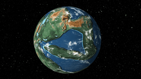


We know that Earth’s surface looked quite different in the geological past thanks to geological maps, fossil evidence, magnetic “compasses” locked in volcanic minerals and supercomputer simulations. Now, courtesy of software engineer Ian Webster, you can use a 3D interactive tool to see how the planet's continents and oceans have changed over deep time in fantastic detail.
The rest of this article is behind a paywall. Please sign in or subscribe to access the full content."Ancient Earth" was created using data from GPlates. This is an open-course reservoir of plate tectonic data that reveals the movements of tectonic plates over Earth’s history. Webster added the visual flair to this data, which means you can see what Earth looked like when the first flowers appeared, for example.
If you’re so inclined, you can type in your address into a search box. If the land is was on existed back then, and it's been tracked through geological time, a dot will appear on the 3D globe, indicating roughly where you would have lived back then.
As noted by Gizmodo, the map defaults to 240 million years before present, when Pangaea was at its most complete and the age of the dinosaurs was just beginning. Here’s the thing, though: as this app demonstrates rather resplendently, Pangaea was hardly the first supercontinent, and it certainly won’t be the last.

The world’s geology is a colossal jigsaw, made of ginormous tectonic plates, and they’re all moving around in different ways. Most things move pretty slowly, on the order of a few millimeters per year.
Such is the case with the East African Rift system, where at a Y-shaped triple junction, the crust is being torn apart. What started 25 million years ago will result in the creation of a new ocean perhaps 10 million years from now, with plenty of weird volcanism featuring along the way.
For reasons that geologists are yet to properly comprehend, there is also the aforementioned supercontinental cycle. When the entirety of the Earth was (possibly) enveloped by ice 700-1,000 million years ago, for example, there was a supercontinent called Rodinia (“Motherland”), which you can see on Webster's app. In a few hundred million years, there will be another supercontinent.
The problem, however, is that although there is a rough pattern to the cycle's timing, much of it remains enigmatic.
At present, authors disagree on what kickstarted it, and what causes the breakups: They’re potentially caused by “bottom-up” processes – mantle events originating at great depth ripping continents apart. On the other hand, they could be split by “top-down” processes; i.e. the subduction and obliteration of tectonic plates.
Continents, particularly older, thick continental landmasses named cratons – like those in Antarctica and Canada – are especially stable. Denser oceanic crust may tumble down beneath less dense continental crust and be destroyed and recycled, but those truly ancient cratons remain.
Volcanic islands are always the baby-aged additions to Earth’s cartography; many that exist today were non-existent back in the days of Pangaea, as Webster's app also shows.
A tectonic plate descending (subducting) under another creates complex, often explosive volcanoes at the surface. Alternatively, superhot mantle plumes rise up into the base of the crust, where they spread out and decompresses, triggering a large degree of melting. If this occurs in the middle of an oceanic tectonic plate, it can generate surface volcanism and land – and that is essentially how the Hawaiian archipelago emerged.
As the tectonic plate continues to drift, but the plume remains essentially stationary, this means that volcanism on Kilauea will ultimately die and its younger sibling, Loihi, in this case, currently an underwater volcano, will rise above the waves.
On a human level, of course, all this means what we take for granted – where we live – is temporary on geological timescales. This was illustrated rather wonderfully back in January: a study found that a tiny town in Australia was built on rock that, once upon a time, used to be in Canada.
[H/T: Kottke]