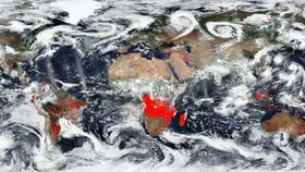


NASA has released a haunting image of the Earth highlighting the number and location of fires across the planet. The image was constructed from satellite observations from the last week and combined in a single image by a NASA software.
Not all the fires have the same origin. In North America and in Chile, they are mostly wildfires. In the South American country, in particular, the cause for the wildfires – which have burned nearly 1.5 million acres in two years – has been at the center of a recent study, published in PLOS One. An international collaboration highlighted how the displacement of native species for more flammable exotic vegetation and tree plantation, thanks to changes in the climate, has exacerbated the problem (or fanned the flames?) of wildfires.
"Unfortunately, fires in central Chile are promoted by increasing human ignitions, drier and hotter climate, and the availability of abundant flammable fuels associated with pine plantations and degraded shrublands dominated by invasive species," co-author Professor Anibal Pauchard, from the University of Concepcion, said in a statement.
In Africa, the fires instead are most likely linked to agriculture and the management of land. It is quite common to used fires to return nutrients to the soil as well, as eliminating unwanted plants. The enriched soil is great for crops and pastures, but fires have the obvious downside of reducing air quality in the area.
Another particular hotspot is Brazil, where researchers believed the detected fires are a mix of agricultural ones and wildfires. In the country, fires are also used as a deforestation tool during the dry season. These purposely started fires can easily spread and burn much longer than anticipated and over a much larger area than planned, especially if the region is experiencing a drought.
The image also shows bushfires in Australia, which thanks to its hot, dry climate and large unobstructed bushlands, have long-reigned. However, bushfire season now begins two months earlier than it used to due to the even hotter and drier summers being experienced in the land down-under.
The image was created using NASA's Earth Observing System Data and Information System (EOSDIS) Worldview application, and you can check out the interactive version here. The system has over 700 global full-resolution imagery layers, such as the fires and thermal anomalies, used in this image. Each data set is updated within three hours of the observation. If you like to keep an eye on planet Earth, this is the tool for you.