


As Hurricane Harvey slowly but surely fades away, the level of destruction and misery left behind by the tropical storm is becoming more and more clear. By August 31, over 27 trillion liters of rain was dumped on Texas, at least 13,000 people have needed rescuing by emergency services, 49,000 homes have been heavily damaged or destroyed, and over 47 people have lost their lives.
The scale is almost unimaginable from just statistics and news casts. But with help of satellite images, you can get a true sense of the enormity of what has happened.
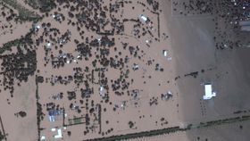
A bunch of new satellite images from DigitalGlobe’s WorldView-2 satellite show the devastating scale of the flooding left in the wake of Harvey over the past week. Vast plains of green land and urban areas are now submerged in brown floodwaters.
"Since Aug. 19, DigitalGlobe’s constellation of five high-resolution imaging satellites has taken 77 images of the Texas coastline, totaling more than 180,000 square kilometers [69,500 square miles] from Corpus Christi to Port Arthur,” DigitalGlobe said in a statement.
"Now that the clouds have parted, the imagery is starting to reveal the vast impact of the flooding across the region."

The images include a variety of areas from Houston and beyond, even include images of the storm-battered Arkema Inc chemical plant, which suffered explosions and a fire on Thursday.
Along with providing some unique insights into the flooding, DigitalGlobe is also using their satellites to help relief efforts back home on the ground.
“DigitalGlobe has mobilized resources within our company to support immediate relief efforts and the long road ahead to rebuild communities in Houston and across the Gulf Coast,” said DigitalGlobe.
“As part of our Open Data Program, DigitalGlobe will publicly release pre- and post-event imagery over affected areas to support disaster response. We are currently tasking all five of our satellites over affected communities as part of our FirstLook crisis response program and are working with partners to incorporate additional sources of data to support relief efforts.”


