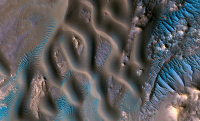


From 300 kilometers (180 miles) above the Martian surface, the HiRise Satellite has produced this astonishing image of sand dunes with tiny ripples on top near the center of the Gamboa Crater in the Mare Acidalium quadrangle.
The rest of this article is behind a paywall. Please sign in or subscribe to access the full content.HiRise can produce images where each pixel represents a piece of Mars less than 30 centimeters (10 inches) wide, allowing us to see objects under a meter (40 inches) across clearly. NASA has taken advantage of this to produce these incredible images on dune tops.
The gap between the closest crests is a few feet, while the larger ripples caught in previous images are around 9 meters (30 feet) apart.
The largest peaks are known as "Transverse Aeolian Ridges" (TAR) and are covered in very coarse sand. At high latitudes it is thought carbon dioxide glaciers may play a part in the formation of ridges like these, but near the Martian equator and in the mid-latitudes their formation is thought to be dominated by wind.

Nevertheless, there is still so much we don’t know about these ridges; scientists have not even settled on a consistent set of names to distinguish different sorts apart.
The colors in the image are enhanced, so we can make out the relative blue of the TARs. Scientists at the University of Arizona tentatively attribute this to their movement under the pressure of the wind, with the removal of darker dust making them look brighter. Remember, in looking at this, and any other image of the effects of the Martian wind, that atmospheric pressure on Mars is just 1 percent of that on Earth.
This may be no pleasure dome and certainly no gardens, but the location is as bright with sinuous rills as anything Coleridge could attribute to Kubla Khan’s creation.