

Thousands of years ago, the Sahara desert was a lush and verdant place more akin to a savannah, where giraffes, hippos, and crocodiles roamed, farmers let their dairy herds graze, and people ate a lot of fish. A vast lake – bigger than the Caspian Sea, the world’s biggest lake today – resided in Central Africa, sprawling 400,000 square kilometers (150,000 square miles), earning it the moniker Lake Mega Chad.
The rest of this article is behind a paywall. Please sign in or subscribe to access the full content.Sometime around 7,000 years ago, the wet, humid land became one of the most inhospitable places on Earth; the vast sandy desert we recognize today. Lake Chad still exists, but it’s a shadow of its former self. Like the rock art and bones that tell us the creatures that once roamed this savannah, evidence of this once-great body of water can still be seen in the ancient shorelines etched into the landscape.
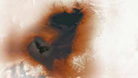
In one of the most spectacular recent images from its Image of the Day series, NASA's Earth Observatory has revealed this incredible view of it from above.

Data from the Shuttle Radar Topography Mission (SRTM) reveals the former shorelines; lower-elevation areas appear darker in the image, while a photo taken by NASA and the United States Geological Survey's (USGS) Landsat 8 satellite locates the present-day lake.
The elevation data also highlight the ridges and sand spits that formed along its northeastern shore. In the Holocene, when Mega Chad thrived, winds blew from the northeast, driving currents that pushed the sand and sediment to build toward the southwest.

Lake Chad still sits inside the shadow of its ancient big sister but it only took a couple of hundred years to shrink to its current 350 square kilometers (135 square miles). Bordered on all sides by Chad, Cameroon, Niger, and Nigeria, around 40 million people rely on the lake for freshwater and resources, meaning that overuse, as well as droughts contributing to desertification, are causing it to shrink further.
NASA's Earth Observatory is a vital tool for studying our planet and even getting a glimpse into our past. We often think of NASA as pointing towards the stars, but when we remember to point the lens back at Earth, not only do we learn invaluable information about our world, it's nice to be reminded that we are also, in fact, rather beautiful to look at too.