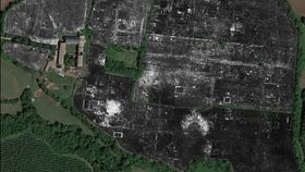


The ancient Roman city of Falerii Novi has been pieced together with the help of ground-penetrating radar beams. It’s the first time the technique has been used to map a complete Roman city and it’s helped to reveal new buildings – all without physically excavating the site.
Reported in the journal Antiquity, archeologists from the University of Cambridge in the UK and Ghent University in Belgium have scanned the ruins of the former site of Falerii Novii in Central Italy. While the site currently consists of a few ancient structures, most notably its wall and entrance gate, the scans were able to highlight scars in the landscape left by buildings that no longer stand and are invisible to the naked eye.
“The level of detail provided by this work has shown how this type of survey has the potential to revolutionize archaeological studies of urban sites,” Professor Martin Millett, study author from the University of Cambridge, said in an emailed press release.

"The use of high-resolution GPR survey generates massive amounts of information, making manual analysis unfeasible,” added Professor Miller.
Falerii Novi is found around 50 kilometers (31 miles) north of Rome and was first founded in 241 BCE by the Romans. Thanks to the Roman’s explementary bookkeeping, much is known about the historical layout despite the fact few of the original structures are still standing. The recent survey consisted of a trailer-mounted GPR that rolled over the field where the town was once found.
The radar beams off the ground and picks up on the reflected waves, revealing the different materials and shapes that are found near the Earth's surface. After 20-odd hours of surveying, the researchers had a complete map of the area. Some of the features highlighted by the recent imaging include a bath complex, a market, and a temple.

Much of what we know about Roman towns comes from the well-studied example of Pompeii, which was famously preserved under a blanket of hot ash from the eruption of Mount Vesuvius in 79 CE. It was always assumed that most large Roman settlements followed a similar layout to Pompeii, but the recent GPR survey of Falerii Novi reveals this might not necessarily be the case.
“There is little doubt that the future application of new analytical methods such as these will fundamentally change the ways in which Roman urbanization is understood,” the researchers say in the conclusion of their study.