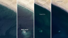


A teensy little mud island off the coast of Pakistan has subsided from sea erosion just six years after forming from an earthquake-triggered mud volcano, reports NASA Earth Observatory.
Zalzala Koh, which means Earthquake Mountain in Urdu, formed in 2013 after a 7.7-magnitude earthquake rocked western Pakistan. Measuring just 20 meters (65 feet) high, 90 meters (295 feet) wide, and 40 meters (130 feet) long, the island was made after the quake triggered a mud volcano – a buildup of sediment caused by tectonic plate activity.
Islands created by mud volcanoes in this area come and go. Each year, the Arabian plate sinks a few centimeters beneath the Eurasian plate, a process known as subduction, which pushes soft sediments onto the edge of the Eurasian plate. Subduction usually creates volcanoes, but the arid region of Pakistan is home to volcanoes that spew mud and methane rather than lava, ash, and sulfur dioxide. The two plates rubbing together builds pressure and intense heat, ultimately melting rocks to magma that conspires with hot volcanic gases to warm the water's subsurface. This process can turn the water acidic to the point of being able to dissolve rock. The hot, gaseous mud mixture can seep to the surface over time and “erupt” to form small mud islands.

These islands don’t last long as tidal influences and pummeling waves eventually wash the sediment away. In the years that followed its creation, Zalzala Koh was tracked by occasional Landsat images from space. By 2016, little was left of the island and satellite images confirmed that the tides of the Arabian Sea had washed the island away.
“Zalzala Koh may be out of sight for now, but that does not mean it is completely gone,” said the space agency in a statement. This year, Landsat imagery picked up traces of the island and just last month scientists spotted sediment trails “circulating around the submerged base.”
Malan Island, also made of mud, is located about 125 kilometers (75 miles) east of Salzala Koh. In the last seven decades, Malan has emerged and disappeared four times, appearing in November 1945 and again in 1999, 2010, and 2013. Similarly, Malan was made up of mud from circular vents that spewed a “mud slurry” and methane gas, according to a 2017 study published in the Journal of the Geological Society of India.