During the Cold War, when tensions were reaching breaking point between the West and the Soviet Union, knowledge was everything. But now the reams of data collected by US spy satellites at the time, and more importantly the images that they took, have been declassified, and they are helping scientists track the retreat of glaciers in remote regions.
There tends to be little information available on the mountains and glaciers of the Himalayas. Public images of the region can show basic changes in a glacier’s area, but a more detailed analysis that shows changes in thickness or mass are trickier to come by. Usually it takes researchers having to physically trek up the rivers or ice and hammer in stakes, and then return year after year, to check on progress.
This obviously has massive limitations, and means that the most remote parts of the mountain range are never monitored. Yet inadvertently, the US spy satellites launched to keep track of the Eastern Bloc had been taking reels of high-resolution images of the entire region. The Hexagon mission included 20 satellites, and carried an impressive 60 miles of photographic film. Once a canister was full, it would be jettisoned, where it would fall to Earth and be intercepted mid-entry by a US aircraft.
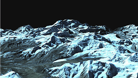
By taking declassified pictures from the Hexagon satellites, which showed the same mountain ranges only from slightly different angles, a graduate student from Columbia University, Josh Maurer, created an automated process that turned these 2D images into 3D renderings, showing how they looked in the late 1970s.
“It can take years for a glacier to fully respond to a change in climate, so looking back several decades gives us a better signal,” Maurer said. “While we have volume changes over the last decade or so from more modern remote sensing platforms, glacier response times can be longer than that. The declassified spy satellite data allows for actual ice volume changes over those longer time scales.”
The 3D renderings have allowed researchers to get the first consistent look at the changes that have been happening to the glaciers in the entire Himalayas over a 40-year period. Maurer has been presenting his results at the American Geophysical Union meeting this week, but early work showed that the state of the glaciers is not looking good. In Bhutan, for example, it seems that the glaciers have been losing an equivalent of 18 centimeters (7 inches) over their entire surfaces per year.