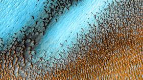


Because Mars is so hot right now, with two rovers vying for best selfie (plus, you know, some ground-breaking science) and a helicopter about to make the first flight on Mars, NASA has released an awesome new image of sand dunes on the Red Planet that are, er, blue.
Of course, the sand on Mars is not actually blue. The false-color image is representative of temperatures on the surface of Mars. The cooler areas are recorded as blue and the warmer features are yellow-orange. The image shows the sand dunes surrounding the northern polar cap, where temperatures can reach -153°C (-243° F) in winter when this was taken. The darker, sun-kissed dunes show their slightly warmer temperatures in golden yellow.
The image is made up of photos snapped by the Thermal Emission Imaging System instrument on the Mars Odyssey orbiter taken between December 2002 and November 2004. In fact, the image is released as part of the 20th anniversary celebrating Mars Oddysey as the oldest spacecraft still working at Mars.
This wind-sculpted sea of dunes surrounding Mars's northern polar cap covers an area the size of Texas, which as the US's second-largest state covers 695,662 kilometers squared (268,597 miles squared). This image covers an area 30 kilometers (19 miles) wide.

Launched on April 7, 2001, the craft – named for Arthur C. Clarke's 2001: A Space Odyssey – was sent to map the composition of Mars's surface. For years, the most complete global maps of Mars we had were made using Mars Oddysey data.
Of course, it's done much more than that, discovering the Red Planet's troves of water ice, mapping the surface for safer future landings, studying Mars's moons, and acting as a "long-distance call center" for Mars rovers, sending their data back home. It's thanks to Mars Oddysey that Earth got images of Mars so quickly when the Spirit and Opportunity rovers arrived in 2004.
Perseverance and Ingenuity may be jaw-dropping at showing how far we've come in exploring another world, but it's good to know a 20-year-old mission still going strong has the ability to take our breath away too.