Advertisement

healthHealth and Medicine
clockPUBLISHED

Before-And-After Satellite Images Show How COVID-19 Has Changed Our Behavior

author

Tom Hale

author

Tom Hale

Senior Journalist

Tom is a writer in London with a Master's degree in Journalism whose editorial work covers anything from health and the environment to technology and archaeology.

Senior Journalist

comments2Comments

Statue of Liberty in NYC on March 11 2020. Satellite image ©2020 Maxar Technologies

As cases of COVID-19 continue to spread across the globe, once-bustling streets in major cities are quickly turning into ghost towns. Airports are grinding to a standstill. Cinemas, concert halls, and theatres are empty. Even New York City's Times Square, the so-called "heart of the world", is eerily quiet.

To get a true sense of this dramatic change, there are better ways than satellite imagery. New images taken by private satellite company Maxar Technologies have documented changes in human activity over the past few weeks in cities, airports, tourist hotspots, and recreational areas all over the world.

Advertisement

From ski resorts to New York City, all locations appear to show distinctly less human activity compared to images taken before the outbreak began in November 2019, or at least before the public started taking precautionary measures to reduce social contact. One exception (that appears to be busier now than earlier in the month) is the airport carpark in Arizona because it shows rental cars laying unused as far fewer people are traveling and using the airport facilities. 

Maxar Technologies is also the company responsible for last week's widely shared satellite images that appear to show Iran digging huge new burial trenches in the wake of the COVID-19. You can view those images here. Before that, check out their latest collection of before-and-after images below. 

Statue of Liberty in NYC on November 4, 2019, before the COVID-19 outbreak. Satellite image ©2020 Maxar Technologies

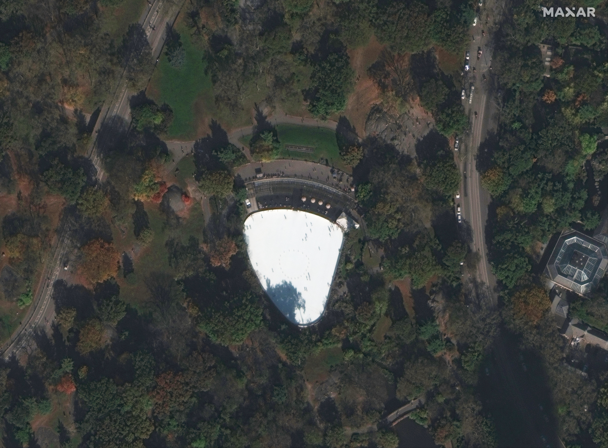
New York's Central Park

Bethesda Terrace and Fountain in New York City's Central Park on November 4, 2019. Satellite image ©2020 Maxar Technologies
Bethesda Terrace and Fountain in New York City's Central Park on March 11, 2020. Satellite image ©2020 Maxar Technologies

Killington Ski Resort

Killington Mountain Resort & Ski Area in the northeast United States, near Killington, Vermont on January 30, 2020. Satellite image ©2020 Maxar Technologies
Killington Mountain Resort & Ski Area in the northeast United States, near Killington, Vermont on March 16, 2020. Satellite image ©2020 Maxar Technologies

Car Rental At Phoenix Sky Harbor International Airport

Phoenix Sky Harbor International Airport in Arizona on March 5, 2020. Satellite image ©2020 Maxar Technologies
Phoenix Sky Harbor International Airport in Arizona on March 16, 2020. Satellite image ©2020 Maxar Technologies

ICe rink in NYC's Central park

Wollman Rink is a public ice rink in the southern part of Central Park in NYC on November 4, 2020. Satellite image ©2020 Maxar Technologies
Wollman Rink is a public ice rink in the southern part of Central Park in NYC on March 11, 2020. Satellite image ©2020 Maxar Technologies

ARTICLE POSTED IN

healthHealth and Medicine
  • tag
  • space,

  • virus,

  • satellite,

  • coronavirus,

  • satellite images,

  • viral outbreak,

  • covid-19

FOLLOW ONNEWSGoogele News