

The Villarrica volcano erupted on March 3, 2015, with a fountain of lava shooting into the sky and drooling down its slopes. The top of Villarrica is blanketed by a glacier cap that covers some 40 square kilometers (15 square miles), according to the Washington Post. That posed a risk of flooding and mudslides for the thousands of people living nearby, forcing them to evacuate the area.
To watch the eruption, check out this video:
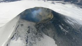
The image below was taken about a week before the volcano erupted.

Image credit: Jesse Allen / NASA Earth Observatory
This image was taken after the eruption. Note the ash on the right side of the volcano.

Image credit: Jesse Allen / NASA Earth Observatory
This image is a composite of two Sentinel-1 scans from February 20 and March 4. According to the European Space Agency, the pink and blue regions indicate changes in the surface of the volcano between those two dates.

Image Credit: Copernicus data/ESA (2015), map produced by the German Remote Sensing Data Center of DLR
H/T: Live Science