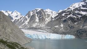
The water melting from Alaskan glaciers and annual snow has been quantified for the first time. The southern portion of Alaska is revealed as discharging one and a half times the volume of the mighty Mississippi. As awe-inspiring as this fact is, the contribution from global warming makes it fear-inducing as well.
If the water was funneled into a single river, the volume rushing off the area south of the Alaskan Range would be world famous, the sixth largest rate of discharge to the ocean on the planet and four times the nearby Yukon. Instead, the 27 million liters per second (7 million gallons/second) is broken up across thousands of small rivers and creeks that reach the Gulf of Alaska before they have a chance to combine. Consequently, until publication in the Journal of Geophysical Research: Oceans, no one had tallied up how much water is being released.
The volume is astonishing because the region being drained is just a sixth the size of the Mississippi basin, and nothing like the tropical climate that fuels giants such as the Amazon and the Congo. However, the high mountains of the Alaskan Range and the Saint Elias and Wrangell Mountains catch the atmospheric moisture, whether as rain or snow.
"Freshwater runoff of this magnitude can influence marine biology, nearshore oceanographic studies of temperature and salinity, ocean currents, sea level and other issues,” says lead author Dr. David Hill of Oregon State University.
Most of this flow has been a longstanding feature of the region, giving the North Pacific plenty of time to adapt to such a huge input of fresh water. However, Hill has shown that 57 cubic kilometers a year (6.7%) of the water is from the melting of glaciers built up over thousands of years. The glacial discharge is more than Missouri River's flow at Kansas City after draining an eighth of America. An additional quantity may be the product of climate change-induced increase in rainfall.
Hill didn't attempt to investigate what effects the glacial melt is having on the oceans or predict the effects of future warming. Instead, he says, “With this data as a baseline we'll now be able to better monitor how it changes in the future." Perhaps more importantly, his methodology will be applicable to other regions.
Hill brought together data from multiple sources, using reports from weather stations and satellites to model predicted runoff. He then compared this with observations from those rivers whose flows are recorded. The strong confirmation bolstered confidence in the technique for watersheds where runoff data is not available. Estimates of glacial loss were based on temperature and evaporation readings over the year and confirmed using the GRACE satellite measurements of ice mass. "By combining satellite technology with on-the-ground hydraulic measurements and modeling, we're able to develop much more precise information over a wider area than ever before possible," Hill says.
More accurate measurements of the rate of ice loss from the much larger icepacks of Greenland and Antarctica is crucial to understanding the dynamics of climate change.