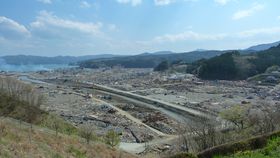


If the world had anticipated the 2004 Boxing Day tsunami, many of the quarter of a million people killed in the catastrophe might still be alive. That didn't happen because we lacked a substantial record of where tsunamis occur, leading people to think the Indian Ocean was safe. To anticipate future disaster, we need the capacity to read the historical record, and the answer may lie in the shape of the gravel these giant waves have left behind.
The rest of this article is behind a paywall. Please sign in or subscribe to access the full content.Tsunamis leave behind a trail of debris that can be used to estimate their frequency in the past, once every 100 to 1,000 years in many locations. However, knowing when they occurred is of only limited value if we don't know how large they were. On the other hand, Japan’s Sanriku coastline has been struck by three major tsunamis (1611, 1896, and 2011) for which we have precise records of how far they reached inland.
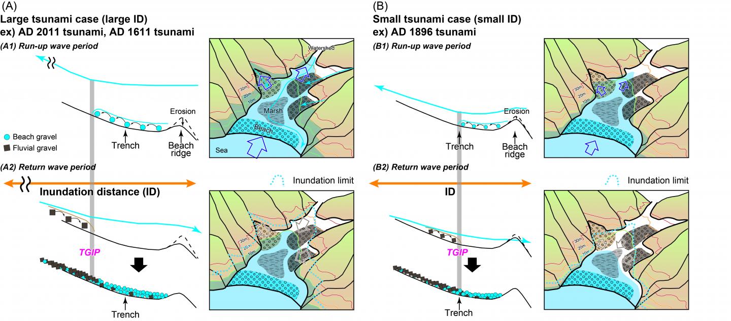
Dr Daisuke Ishimura of Tokyo Metropolitan University collected gravel greater than 2 millimeters (0.08 inches) in diameter left behind by each of these events from bore holes and a trench in the Koyadori Valley above the Sanriku coast. These were compared with similar material from nearby beaches and the river valley. “The gravel particles of the beach sediments were rounded, reflecting abrasion by sea waves, and those of the fluvial sediments were angular,” he writes in Scientific Reports.

Using automated image analysis, Ishimura calculated a roundness value for each piece of gravel using a long-standing definition and compared these for locations at different distances from the sea. Close to the shore, the dominant material was from the beach, brought in by the incoming waves. Further inland, there were more river stones carried by the returning tsunami as it headed back to the ocean.
Within the steady trend, however, Ishimura found a sharp change in each of the tsunamis, where river material jumped from 25 to 40 percent. He named this the "tsunami gravel inflection point" (TGIP). Crucially, the TGIP in each case was located about 40 percent of the way from the shore to the peak inundation point. Using this information, Ishimura estimated the size of tsunamis that battered the same coastline as far back as 4,000 years.
Ishimura and his author don't think TGIP lies two-fifths of the way to the inundation peak everywhere tsunamis strike – the shape of the local topography will affect how far up it lies. Nevertheless, if there is a consistent ratio of TGIP to maximum inundation point for each location, their work offers an opportunity to start estimating past tsunamis at different locations, which will help engineers calculate the size of the events they need to build defenses against.