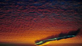


What you're see here is a fall streak hole, which almost looks like a scar cut into the sky. It's an elongated version of hole punch cloud.
Darcey Middleton
Both odd cloud formations have been sighted over the Pacific Northwest in recent weeks, although no one is entirely sure why they've been appearing more regularly. The National Weather Service Office based in Wisconsin explains the phenomena’s in more detail:
"High to mid-level clouds, such as altocumulus, are often composed of tiny water droplets that are much colder than freezing, but have yet to freeze. These 'supercooled' water droplets need a 'reason' to freeze, which usually comes in the form of ice crystals. Planes passing through the cloud layer can bring these ice crystals. "Once the ice crystals are introduced, the water droplet quickly freeze, grow and start to fall. A hole is left behind, which will start to expand outward as neighboring droplets start to freeze."
Check out this time lapse footage caught by Andy Brown of dual fall streaks moving across the sky