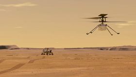


NASA’s Ingenuity, the first aerial vehicle to take flight on another world, continues to be a story of monumental success. Being a pathfinder mission it was designed to last 90 days and five flights. Now many months later, having completed its 13th flight, the helicopter continues to fly higher and further than hoped.
The 13th flight was completed on September 5, where the helicopter moved slower, over a shorter distance, and at a lower altitude than the several previous aerial jaunts. And for good reason, Ingenuity is studying a particular ridge in the geologically intriguing location of South Séítah. This will inform where the rover Perseverance might go next.
Flight 13 covered 210 meters (690 feet) in about 161 seconds moving at a speed of about 3.3 meters per second (7.2 mph). That’s less than half the distance covered in the last flight and its slowest and lowest since early May. The helicopter took 10 photos all aimed in a particular direction.
“For Flight 13, we’ll be capturing images pointing southwest. And when they’re combined with Flight 12’s northeast perspectives, the overlapping images from a lower altitude should provide valuable insight for Perseverance scientists and rover drive planners,” Teddy Tzanetos, Ingenuity Team Lead at NASA's Jet Propulsion Laboratory wrote in a blog post for NASA.

Ingenuity’s work has been crucial for directing Perseverance. When deciding where to send a rover, scientists can look around and use satellite images to find interesting areas. South Séítah is one of these but the images taken by Ingenuity in-flight tell a deeper and richer story than the expectation from satellite observations.
“From a science perspective, these images of South Seítah are the most valuable Ingenuity has taken to date,” Ken Farley, the project scientist for NASA’s Perseverance rover, said of images taken in the 12th Flight in a statement. “And part of their value may be in what they are not showing. Sedimentary layers in rocks are not readily apparent in the image, and there may be areas that could be difficult to negotiate with the rover. There is work to do by our science and rover driving teams to understand better how to respond to the new data.”
Combining the images will allow the science team to work out if the area of Artuby Ridge – where Perseverence is currently exploring – is worth sticking around for the first science campaign, or if there is something at South Séítah that is more valuable to explore.