

From the air, the Amazon rainforest looks like one continuous swath of green as far as the eye can see. But for the first time, scientists have been able to show that it’s actually a lot patchier then you might assume. They have mapped sections of the forest by imaging the canopy chemistry, and have revealed a mosaic pattern of distinct communities of trees grouped by the chemicals in their leaves.
The rest of this article is behind a paywall. Please sign in or subscribe to access the full content.The team, from the Carnegie Institute for Science, think that this pattern reflects the underlying geology and hydrology of the different regions. This knowledge could potentially have an impact on understanding how the Amazon has grown, and how the ecosystem functions on a larger scale. The study is published in the journal Nature Geoscience.
“Our findings tell us that lowland Amazon forests are far more geographically sorted than we once thought,” explains Greg Asner, lead author of the paper. “It is not simply a swath of green that occurs with everything strewn randomly. Place does matter, even if it all appears to be flat and green monotony at first glance.”
They mapped four huge regions of southwestern Amazonia along the Madre de Dios and Tambopata Rivers in lowland Peru. Their work revealed how the chemical signatures in the trees changed along the paths of the rivers, as well as with even slight changes in elevation. They were able to find that trees bordering the rivers were higher in growth chemicals compared to those further away. The maps also help to explain the pattern of carbon dioxide uptake across the lowland Amazon.
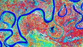
The video below shows how the forest changes dramatically when imaged by the chemicals found within the leaves.
The researchers collected data on board the Carnegie Airborne Observatory, a plane specially fitted with an array of sensors and equipment used to map the Earth’s surface like never before. Using this data, scientists are able to build up 3D pictures of whole forests and landscapes, and with imaging spectroscopy they can map the chemistry found in the trees. Imaging spectroscopy works by measuring the range, or spectrum, of wavelengths of light that are reflected off the foliage. Then, using the differences in these recorded signatures, researchers can define the chemicals found in the leaves.
“This is the first time that so many chemicals have been measured and mapped in any forest ecosystem on Earth,” Asner said. “No one has done the mapping we have achieved here, which enabled a discovery that the lowland Amazon is anything but monotonous or similar everywhere.”
Trees produce different chemicals in their leaves for a whole host of reasons. Their chemical composition changes in response to predators, in order to attract pollinators and during growth, to name a few. Leaf chemistry can also be influenced by other environmental factors like the geology of the region and climate change. Studies have shown that such differences can affect a plant's ability to grow and produce biomass, and those that are able to produce more of the necessary chemicals will be better equipped to adapt to climate change.