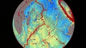


Using gravitational field data collected from European Space Agency (ESA) and NASA satellites, researchers from the Scripps Institution of Oceanography have started producing the most accurate maps to date of one of the least explored areas on Earth: the bottom of the ocean. And they’ve already started churning out some remarkable findings, including thousands of previously unknown mountains and even new hints about continent formation.
As described in the journal Science, the findings were made with the assistance of radar altimeters installed on ESA’s CryoSat-2 and NASA’s Jason-1 satellites. These instruments continuously bounce signals off the surface of the ocean which reveal its shape. Since water follows gravity, features at the surface reflect what lies at the bottom. Undersea mountains, or seamounts, for example, exert gravitational pulls and thus warp water outward above the feature. Deep trenches, on the other hand, would cause the water to do the opposite. By combining these measurements with existing data, the researchers were able to generate a model that is twice as accurate as previous models.
While the researchers have barely touched the surface yet, their new map has already revealed a wealth of new information. Among the findings so far are thousands of previously unchartered seamounts, up to a kilometer and a half in height, and an extinct spreading ridge where tectonic plates were pulling apart some 180 million years ago to form a basin that became the Gulf of Mexico. In the South Atlantic Ocean, they also discovered previous continental connections from before South America and Africa rifted apart some 85 million years ago.
Although maps of the seafloor existed before this project, they largely relied on information gleaned from ship-based sonars. Given that ships would only scour certain regions, there existed large gaps in the data. Furthermore, much of the topography of the ocean floor is buried by thick sediment which instruments struggled to penetrate. This left some 80-90% of the seafloor unchartered, meaning that scientists actually know more about the surface of Mars than the bottom of the ocean. Hopefully, as the team continues to gather more information, we might start to see that change.
[Via UCSD, BBC News, Science and Sciencemag]