
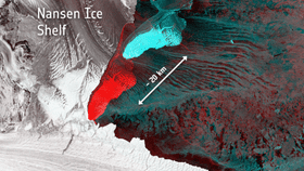


Multiple satellites have captured the moment an ice shelf fractured and “gave birth” to two huge icebergs, one of which is around 10 kilometers (6 miles) long and the other 20 kilometers (12 miles).
The European Space Agency has released the images showing the Antarctic’s Nansen ice shelf earlier this month. They depict a fracture that occurred in a bay in the east of Antarctica, south of New Zealand, which spawned the two icebergs.
The crack in the ice shelf was first noted in 1999, but has accelerated its growth since 2014, according to Massimo Frezzotti from Italy’s ENEA research organization. Researchers observed a particularly noticeable increase in size in early March, when the Antarctic’s winter comes in. The final push started on April 7, when two days of strong offshore winds managed to sever the icebergs from the ice shelf.
Throughout this process, Europe’s Sentinel-1A and 2A satellites, and NASA’s Terra satellite, have been keeping tabs on the situation, eventually managing to catch the money shot of the final split.
The two icebergs are now drifting north-eastwards, moved along by winds, tides and currents, although it’s not thought that they pose any threat to supply routes to the south pole.
This kind of activity is not as uncommon as you may think. Frezzotti explained in an ESA statement, “History has shown that major calving typically occurs about every 30 years. The crack opened because of a difference in the velocity of ice between the northern Priestley Glacier and southern Reeves Glacier fed portions of the ice shelf, caused by the southern part being hooked and pulled along by the faster moving Drygalski Tongue.”

A week's worth of radar image data captured by the Sentinel-1A satellite. Copernicus Sentinel/ESA


