
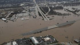


When flooding hit Missouri at the end of 2015, it took some people off-guard. In a matter of hours, up to 25 centimeters (10 inches) of rain fell over the state (as well as in southern Illinois), causing flash floods that lead to at least 24 deaths. Many of those who lost their lives were trapped in their cars as the flood water swept through. But rather than blaming the large amount of rain that unexpectedly dropped on the region for the floods, a new study claims that it was actually the result of badly planned engineering works.
The rest of this article is behind a paywall. Please sign in or subscribe to access the full content.“The heavy rainfall was probably related to El Niño, and possibly intensified by global warming,” explains Robert Criss, author of the study published in the Journal of Earth Science, in a statement. “But new records were set only in areas that have undergone intense development, which is known to magnify floods and shorten their timescales.
"People want to blame the rain, but this is mostly us. It's a manmade disaster.”

The flooding was the worst recorded in some regions along the Meramec River. Jessica Sutton/Flickr CC BY-NC 2.0
The study says that previous large floods in the region, namely one that occurred in 1982, behaved in a different way despite being of a similar scale. The water level in 2015 was shown to be around a meter (3.3 feet) higher than it was 33 years earlier at the peak of that flood. So what exactly changed in the region between then and now? The study found that there were four main projects that seem to have exacerbated the impact caused by the deluge.
To start with, a 4.8-kilometer-long (3-mile-long) levee, built to prevent the overflow of the Meramec River, had been constructed along the course of the river. A landfill built on the river's floodway had expanded in size, as had the construction of buildings on the water courses floodplain. Finally, three tributaries of the Meramec River experienced extensive development, meaning that while they are normally dry, they become torrents when it rains.
All this has the effect of preventing the river from flooding at these particular locations – where the water would normally naturally spread out – and increasing the speed of the river that then dumps the water on communities further downstream. “The biggest jump in the flood stage was next to the landfill in the floodway and to the new levee, which restricted the effective width of the floodway and '100-year' floodplain by as much as 65 percent,” says Criss.
A lot of news outlets were quick to claim that the severe flooding and record-high river levels were due to the sudden, unexpected amount of rain falling, and yet this study shows that this explanation did not fully explain what was experienced. What needs to happen is for authorities to take into account how man-made changes to the environment and river system can heavily impact the flooding risk of a region.
Main image: Missouri National Guard/Flickr CC BY-NC 2.0