


There is a lot we don’t know about the Arctic and the Antarctic's ice cover, which sucks, frankly. Not only are they biodiverse, beautiful parts of the world, but they’re also variably impacted by climate change, and their complex reactions to it reveal much about the future of our interconnected planet.
That’s why NASA’s Operation IceBridge is so utterly marvelous: Not only does it provide scientists with a unique way to study the northernmost and southernmost realms of our world, but it’s an unparalleled tool for science communication too. What better way to convey the wonders and enigmas of the Arctic and the Antarctic to the general public than through jaw-dropping imagery like this?
The airborne mission has stepped in to temporarily replace the delayed sequel to the Ice, Cloud and Land Elevation Satellite (ICESat) mission. It’s spent its time zipping over the planet’s polar ice, particularly that belonging to the Greenland and Antarctic ice sheets, and taking some glorious shots of them, probing their rapid evolution over the last few years.

Lately, in April and May, several additional research flights have been carried out over the Arctic for IceBridge's annual springtime survey. We’ve featured some of the most striking shots taken by these 20 flights, but you can view far more if you pop on over here. Some were taken by the plane's equipment, while others were taken by DSLR cameras – or even iPhones – pointed out of the window by the crew.

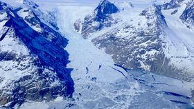
As you can see, the shots paint a vivid picture of a fragmented region of blues and whites, of crevasses and cracks; it's an ephemeral jigsaw that becomes more intricate as the mercury rises ever faster.

According to an accompanying press release by NASA, IceBridge this time around was based out of Thule Air Base in northwest Greenland, Fairbanks, Alaska, and out of Kangerlussuaq in central west Greenland just north of the Arctic Circle.

Eight flights were dedicated to surveying sea ice, and 12 looked at land ice. At the same time, collaborations with several international endeavors were undertaken, including with ESA’s Sentinel-3a and Cryosat-2 satellites, the US Navy’s ICEX missions in sea ice north of Alaska, and more.

All flights involved NASA’s P-3 Orion plane, equipped with infrared, photographic, and radar-based imagery that provides researchers with an opportunity to determine temperatures, topographical changes, and more. This fresh information will be compared to previous flights’ data, which when put together will help scientists determine how ice cover has changed over time.

The briefest of looks at the project’s official website reveals how busy the program has been. Maps covered in multicolored lines reveal hotspots of research, including the Antarctic Peninsula and much of the entirety of the coastline of Greenland.


ICESat-2, the successor to the original, will begin operations this September, and these flights are to be the last to occur before then. Don’t fret, though; NASA aren’t going to suddenly just throw IceBridge in the dustbin of scientific history. At present, the 2009-launched project is funded through to 2020.


