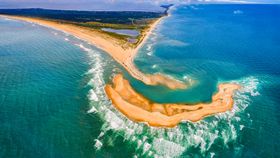


Hey, remember that awesome island that formed off the coast of North Carolina last month? Well, NASA has just snapped some images of it from space.
The images were taken by the Operational Land Imager (OLI) on NASA’s Landsat 8, which orbits at an altitude of about 705 kilometers (438 miles). They reveal how by July of this year, an entirely new island had been created.
NASA’s photos show that the island began forming as far back as November 2016. Another image in January 2017 showed waves were breaking in the region, where the island eventually formed.
The island shot to fame in June when Chad Koczera, a 30-year-old aerospace engineer from Connecticut, used a drone to capture images that were then widely shared. Locals named it “Shelly Island”, as there were a large number of untouched seashells on it.
It’s thought that a storm caused the island to appear, churning up the seabed and bringing in new sediment. It’s not too unusual for a landmass like this to emerge, but one of this size – more than a kilometer long – is quite rare. This location, Cape Point, is where the southbound Labrador Current hits the warmer gulf stream, leading to rough waters and storms that can cause dramatic changes.

“What exactly causes a shallow region to become exposed is a deep question and one that is difficult to speculate on without exact observations,” said Andrew Ashton, a geomorphologist at the Woods Hole Oceanographic Institution, in a NASA statement. “A likely process would be a high tide or storm-driven water elevation that piled up sediment to near the surface, and then water levels went down exposing the shoal. Waves then continue to build the feature while also moving it about.”
NASA also noted that the shoreline here is in constant motion. Waves sculpt the appearance of the cape tips in this region, and sediment is constantly being carried up and down.
Shoals associated with the capes can also extend for tens of kilometers under the ground and can be just a few meters deep in places. So this place is ever-shifting, although that shouldn’t make Shelly Island any less impressive.