


Because the world was absolutely not satisfied before, NASA has released even more images of that baffling, nearly perfectly rectangular-shaped iceberg.
You may recall the first image, which was taken by the NASA’s IceBridge, a fleet of research aircraft dedicated to studying Earth’s polar ice by measuring annual changes in thickness of sea ice, glaciers, and ice sheets. It’s the longest-running aerial ice survey and it aims to “understand connections between the polar regions and global climate system.”
On October 16, the polar plane took off to assess changes in Larsen A, B, and C but our peculiar iceberg quickly stole the show after the space agency posted it to social media. The too-good-to-be-true rectangular iceberg was spotted near the Larsen C, the Delaware-sized ice shelf famous for breaking off the Antarctic Peninsula in July 2017.
“I thought it was pretty interesting; I often see icebergs with relatively straight edges, but I've not really seen one before with two corners at such right angles like this one had,” Jeremy Harbeck, IceBridge senior support scientists, said in a statement.
The newly-released image shows the edge of our new favorite iceberg, another slightly less squared iceberg, and A68 (Larsen C’s long-lost iceberg child) in the distance.
“I was actually more interested in capturing the A68 iceberg that we were about to fly over, but I thought this rectangular iceberg was visually interesting and fairly photogenic, so on a lark, I just took a couple photos,” Harbeck said.
This show-stopping tabular iceberg is an estimated 1.6 kilometers (1 mile) across with clean edges that indicate it had probably broken off fairly recently, reported Science Alert. But how does an iceberg take on such a uniform shape?
Icebergs form when the weight of large chunks snap off, or “calve,” from glaciers, ice shelves, or even larger icebergs, explains the National Snow & Ice Data Center. Though they may appear too perfect to be formed by nature, “tabular” icebergs are relatively common, such as the Pobeda Ice Island that forms periodically off the coast of East Antarctica by a tabular iceberg running aground.
Non-tabular icebergs are the ones we tend to think about in the more traditional sense, but our steep-sided and flat-topped friends have something in common with their more recognizable cousins: they likely take on a more geometric shape below the surface, making them just as hazardous for passing ships.

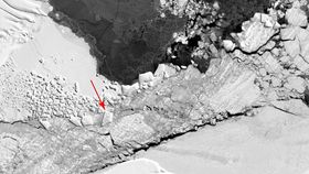
Just past the rectangular iceberg, which is visible from behind the outboard engine, IceBridge saw another relatively rectangular berg and the A68 iceberg in the distance. NASA/Jeremy Harbeck


Large tabular icebergs located between Antarctica's Larsen C ice shelf and the A-68 ice island, which calved off of the Larsen C last year, as seen on a NASA Operation IceBridge mission on Oct. 16, 2018. NASA/Jefferson Beck


