

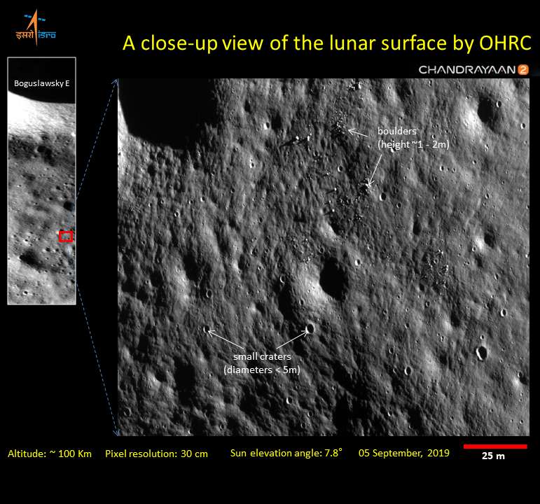
India's Chandrayaan-2 lunar orbiter is hard at work studying the surface of the Moon. ISRO, the Indian Space Research Organization, has released some images and new data collected by the craft, pointing out that the new pictures are the sharpest ever taken from orbit.
The images were taken on September 5 and cover part of the Boguslawsky E crater, which is 14 kilometers (8.7 miles) across and 3 kilometers (1.9 miles) deep. This is one of the 14 satellite craters of the much larger Boguslawsky crater. Each satellite has a capital letter after its name, with the letters ordered to denote distance from the main one.
Chandrayaan-2 used its Orbiter High-Resolution Camera to snap the photos from an altitude of 100 kilometers (62 miles). The image covers a swath of a few kilometers and has an incredible spatial resolution of 25 centimeters (9.8 inches), enough to spot meter-sized boulders and craters that mark the desolate surface of our natural satellite. NASA's LRO has a similar high-resolution capability but the final images aren't always as sharp.
The high-resolution images will be key to achieving one of the mission's goals – to map the lunar surface with even more detail than before to construct 3D maps. One of the mission's other objectives is strongly connected to the subject of the released photos. The region photographed by the craft is near the lunar south pole which is of particular interest for scientists because it is rich in water.
The Indian mission will use its radar to study the distribution of water ice on the south polar region and measure the thickness of the lunar regolith, the fine dust soil that covers the Moon.

ISRO has also released data from its CLASS instrument, an X-ray spectrometer. It studied the elemental composition of lunar soils by detecting X-rays emitted by the Sun bouncing off the lunar surface. For this reason, it works best during solar flares.
But the instrument doesn’t sit idle when the Sun is quiet. The team uses it to measure the number of particles encountered by the Moon in the six days that it crosses the geotail, the magnetic field of the Earth stretching away from the Sun. The preliminary data shows a 10-fold increase in particles in this region of space, suggesting a complex interplay between electrically charged particles and the magnetic field.
Chandrayaan-2 also delivered a lander to the surface of the Moon, but in the final minute of descent, something went wrong.