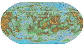


This has been a good week for Mercury. Millions of people around the world observed the little planet transit across the solar disk on Monday, and now NASA has released the first topographic model of the planet.
The digital elevation model (DEM) was constructed from data taken by the MESSENGER probe’s Mercury Laser Altimeter, and it shows a large variety of interesting features. The highest point on Mercury is 4.48 kilometers (2.78 miles) above the average elevation, with the lowest being 5.38 kilometers (3.34 miles) below average, found within the Rachmaninoff basin.
The MESSENGER mission studied Mercury from 2011 to 2015, and NASA has so far shared more than 10 terabytes of data, including nearly 300,000 images and millions of scientific measurements. Among the many discoveries made by the probe was the first visual evidence of extensive volcanism in Mercury's recent past.

A view of Mercury’s northern volcanic plains from the new map are shown in enhanced color to emphasize different types of rocks on Mercury’s surface. NASA/Johns Hopkins University Applied Physics Laboratory/Carnegie Institution of Washington
A map of the lava-covered terrain in the north pole of the planet was released together with the DEM. The lava deposit is about 2 kilometers (1.2 miles) thick and it covers an area equivalent to 60 percent of the continental United States. Another important feature of Mercury’s north pole is the presence of organic molecules and water ice in its permanently shadowed craters.
“This has become one of my favorite maps of Mercury,” Nancy Chabot, one of MESSENGER’s scientists, said in a statement. “Now that it is available, I’m looking forward to it being used to investigate this epic volcanic event that shaped Mercury’s surface.”
The latest information about Mercury was released by the Planetary Data System, whose job is to archive and distribute all of the data collected by NASA’s missions to other planets. MESSENGER’s mission ended last year when the probe was deorbited (as planned) and crashed on Mercury. While the mission is complete, there's still much hiding in the data.
“MESSENGER’s scientists and engineers hope that data from the mission will continue to be utilized by the planetary science community for years to come, not only to study the nature of the innermost planet, but to address broader questions about the formation and evolution of the inner Solar System more generally,” added MESSENGER Principal Investigator Sean Solomon, director of Columbia University’s Lamont-Doherty Earth Observatory.