
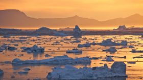


Greenland lost around 600 billion tons of ice during the exceptionally warm Arctic summer of 2019, enough to raise global sea levels by 2.2 millimeters in two months. While much of this water would have returned back into ice once winter came around, the remarkable scale of thawing is certainly a cause for concern.
New research led by the University of California, Irvine (UCI), and NASA has used satellite gravity measurements to assess the thickness and span of ice sheets in both Greenland and Antarctica. Reported in the journal Geophysical Research Letters, the team estimated that Greenland lost 4,550 billion tons of ice between 2002 and 2019, an average of 268 billion tons annually. The rate of melting appears to be on the increase too, with last summer's losses in Greenland equaling more than double the yearly average between 2002 and 2019.
"We knew this past summer had been particularly warm in Greenland, melting every corner of the ice sheet. But the numbers really are enormous," lead author Isabella Velicogna, senior project scientist at NASA's Jet Propulsion Laboratory and a professor at UC, said in a statement.
Meanwhile, on the opposite end of the planet in Antarctica, there’s a slightly more complex picture. Antarctica has continued to lose mass in the Amundsen Sea Embayment and Antarctic Peninsula in the western part of the continent. However, much of this is often set by increased snowfall in Queen Maud Land in the eastern part of the continent.
"In Antarctica, the mass loss in the west proceeds unabated, which will lead to an even further increase in sea level rise," adds Velicogna. "But we also observe a mass gain in the Atlantic sector of East Antarctica caused by an uptick in snowfall, which helps mitigate the enormous increase in mass loss that we have seen in the last two decades on other parts of the continent."
All of these statistics come from the researchers establishing data continuity between data gathered by the Gravity Recovery and Climate Experiment (GRACE) satellite mission and its successor, GRACE Follow-On. Fortunately, all of the data appeared to neatly line up, suggesting their findings were on the money.
“It’s great to see how well the data line up in Greenland and Antarctica, even at the regional level,” continued Velicogna.
Using two identical satellites that fly about 220 kilometers (137 miles) apart in a polar orbit 500 kilometers (310 miles) above Earth, the GRACE mission maps subtle variations in Earth's gravity field, giving insights into how mass is distributed around the planet and how it varies over time. Data from the mission has been used to gain unprecedented insights into Earth’s ocean, geology, climate, and – of course – ice sheets.
In one of its more recent endeavors, the GRACE twins were used to analyze the state of Earth’s freshwater sources. Just like this recent project, the findings are a cause for concern.


