

Incredible satellite imagery captured by a collaborative effort between NASA and the US Geological Service shows how captivating – and changing – our planet is.
Started in the early 2000s, the Earth As Art project set out to do just that: capture satellite images that show the planet as a piece of art. Earth As Art 6 now includes images from USGS drones equipped with sensors capable of capturing both visible and infrared light. When combined with the imagery captured by satellites orbiting Earth, these drones have proven a valuable asset to monitoring change over time and allow us to see wavelengths of light not visible to the naked eye.
“Earth has a stunning variety of landscapes. The colors, patterns, textures, and shapes all make for intriguing artwork as seen from the perspective of space,” a representative from the USGS told IFLScience. “Earth As Art shows not only what satellites can see with visible light that you and I can see, but also the invisible wavelengths that the sensors can detect in the infrared part of the spectrum. It’s those combinations that bring out breathtaking beauty and even much more scientific value.”
Don’t just take our word for it. See for yourself.

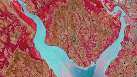
Rapid Ice Movement captured June 24, 2018. USGS
This Russian glacier in the Arctic Ocean has been changing rapidly in recent years after decades of “normal, slow movement”. Since 2013, the ice tongue has doubled in size. This image is inverted, showing the land in blue and fractured sea ice as a tan coloring.

Palmyra Atoll captured October 21, 2016. USGS
This remote ancient volcanic atoll is located around 1,000 miles from Hawaii and is currently managed as a science and research station. The image shows vegetation as blue and the ocean and coral reefs in a yellowish-green.

Blue Ice captured February 18, 2018. USGS
Blue ice is seen near the Queen Fabiola Mountains, or the Yamato Mountains, in Antarctica. Here, blue ice emerges when wind cleans glaciers of their snow and air bubbles are squeezed out of partially compacted snow. The ice shows as blue because red and yellow wavelengths of light are absorbed.

Fanned Out captured February 22, 2019. USGS
Water from the Balkh River is shown as it fans out into an agricultural area in northern Afghanistan.

Irritated captured February 6, 2019. USGS
In Africa’s Western Sahara, an intense network of water drainage courses is seen stretching west toward the Atlantic Ocean.

A Study in Algae captured September 14, 2016. USGS
Algal blooms, which can be harmful to fragile wetland ecosystems and humans, were captured on Milford Lake in Kansas using a drone system.

Torn Apart captured March 31, 2017. USGS
The image shows three tectonic plates as they shift away from each other in northeastern Ethiopia. New fissures opened at this volcanic region in January 2017 and an image taken by Landsat 8 just two months later shows the locations of the fresh lava.

Watching Wetlands captured August 15, 2017. USGS
This natural-color image was captured by a drone above a high-altitude wetland called a fen in the Rocky Mountains of Colorado.

Re-entry captured April 19, 2019. USGS
As if something entering the Earth’s atmosphere, a large granite dome known as Jebel Kissu in northwestern Sudan dramatically juts out from the Sahara Desert.

Desert Ribbons captured February 6, 2019. USGS
Ribbons of rock across northwestern Africa are the result of prolonged collisions between tectonic plates.

Outburst captured March 22, 2017. USGS
In southern Iceland, the Skeiðarárjökull glacier experiences flooding events that take with it vegetation (red) such as moss, birch shrub, and other grass species.
View the full Earth As Art 6 gallery here.