

Spectacular images captured of Mars' “Grandest Canyon” are providing the level of distraction we all need right now.
The rest of this article is behind a paywall. Please sign in or subscribe to access the full content.They show the swirly, mesmerizing Martian surface of the plains north of Juventae Chasma, a southwestern part of the Valles Marineris – the Solar System’s largest canyon. Valles Marineris, or Mariner Valley, is a vast canyon system that runs along the Martian equator measuring 4,000 kilometers long (2,500 miles) and reaching depths of up to 7 kilometers (4 miles) – nearly five times the size of the Grand Canyon in Arizona, according to NASA. This dramatic environment spans about 20 percent of the entire distance around Mars, or as long as the United States.
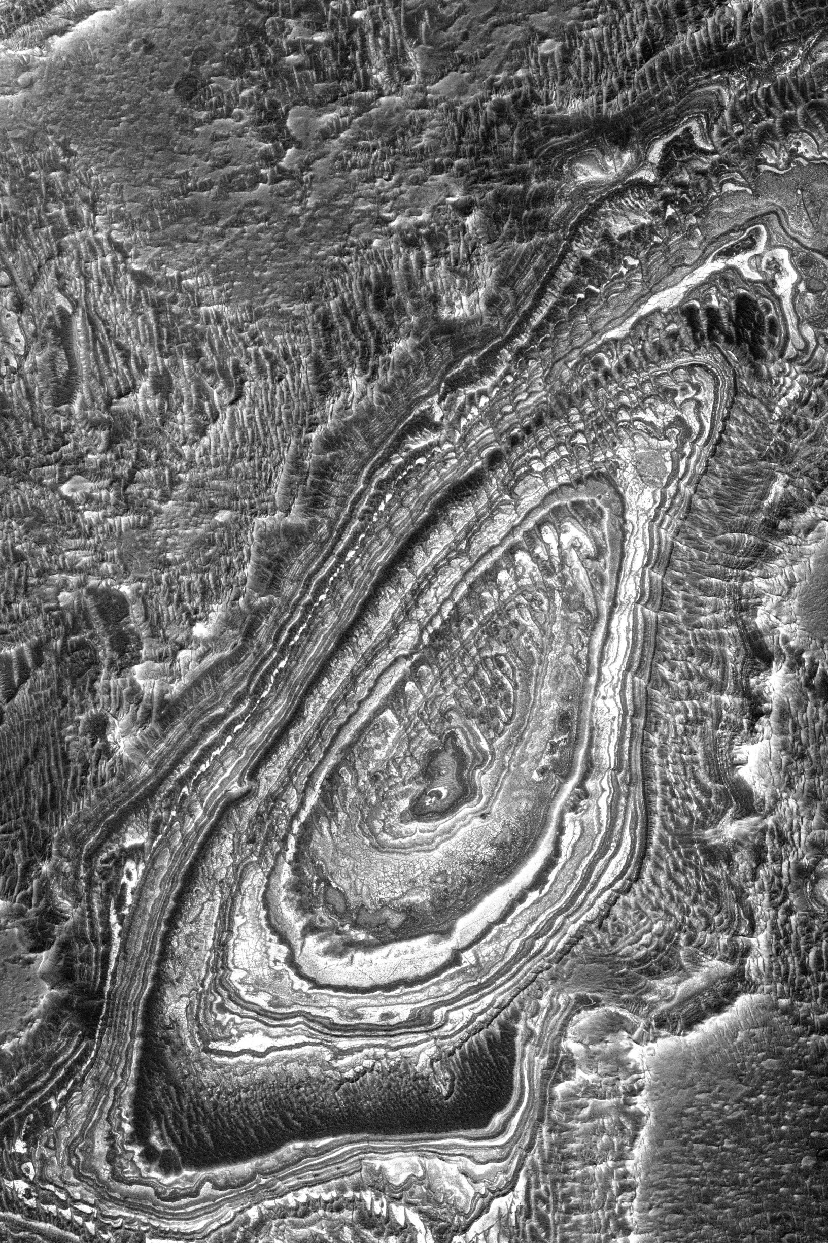
According to a press release by the University of Arizona, the first image below captures three types of terrain. The top half shows craters and “sinuous ridge features,” which may be inverted stream channels that occur when low-lying areas become lifted. Such lifting may be the result of streambeds that fill with lava or material contained within become cemented from precipitating minerals, both of which are resistant to erosion. On the other hand, fine-grained material like sand is blown away by wind or carried by water, which leaves the elevated regions “high and dry.”
The bottom two-thirds of the image shows the canyon’s plains in light and dark tones measuring about 1 kilometer (0.6 miles) across. Over time, erosion has revealed these layers, which are common across Mars, but their source remains a bit of a mystery. The smallest rings expose the plains’ deepest layer. A second black-and-white image shows the layers on a wall of Juventae Chasma, a large depression in the Martian surface partially covered by dunes.

It is unclear how this enormous canyon formed, but experts generally agree that it is the result of a large tectonic “crack” in the Martian crust that formed as the planet cooled. Channels, streambeds, and other nuances in the formation may have been the result of rising crust in the volcanic Tharsis region to the west, erosional forces over time, and the flowing of water.
The images were taken by the Mars Reconnaissance Orbiter (MRO) in 2007 using its advanced imaging instrument, the High-Resolution Imaging Experiment (HiRISE) camera whose sole purpose is to take photos of the Martian terrain, capable of seeing features as small as your kitchen table. MRO has been in operation since March 2006 to “advance our understanding of Mars through detailed observation, to examine potential landing sites for future missions, and to provide a high-data-rate communications relay for those missions,” according to a mission overview. HiRISE takes images from an altitude of 300 kilometers (186 miles) with the ability to capture features as small as a meter across (3 feet).
“The camera operates in visible wavelengths, the same as human eyes, but with a telescopic lens that produces images at resolutions never before seen in planetary exploration missions,” writes the space agency.