


Scientists have pinpointed Earth’s deepest canyon on continental land: the Denman Glacier, a trough that reaches 3.5 kilometers (2.2 miles) below sea level. It lies hidden deep beneath a tomb of glacier ice in East Antarctica.
The trench's depth was discovered as part of a new study by an international team of glaciologists who set out to map the contours of the Antarctic continental land. The team used ice thickness data from 19 different research institutes combined with masses of radar data to peek beneath Antarctica's ice sheets, a similar methodology to what's been used to study Greenland in recent years.
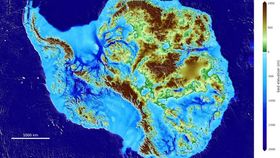
Reported in the journal Nature Geoscience, the result is the most accurate portrait yet of Antarctica's contours, dubbed BedMachine, which is publicly accessible through the US National Snow and Ice Data Center. The research was also presented at the American Geophysical Union's Fall Meeting this week.
Along with the Denman Glacier – the deepest trench on land – the findings also offered a number of previously unknown topological insights into what lies beneath Antarctica's ice.
"Older maps suggested a shallower canyon [beneath the Denman Glacier], but that wasn't possible; something was missing," lead author Mathieu Morlighem, associate professor of Earth system science at the University of California, Irvine, said in a statement.
"With conservation of mass, by combining existing radar survey and ice motion data, we know how much ice fills the canyon – which, by our calculations, is 3,500 meters below sea level, the deepest point on land," he added. "Since it's relatively narrow, it has to be deep to allow that much ice mass to reach the coast.
"There were lots of surprises around the continent, especially in regions that had not been previously mapped in great detail with radar."
The goal of this project wasn’t just to create a pretty map. The team hopes their work will be used to understand how Antarctica’s ice sheets will respond to the effects of climate change and which regions are going to be more vulnerable to warming temperatures.
“BedMachine is a major step forward in refining the fine-scale topography hidden beneath the ice sheet, so that we can better model how it will respond to warming, and reduce the uncertainty in sea level rise projections,” Australian Antarctic Division glaciologist Dr Tas van Ommen said in a statement.
In case you're still curious, there are actually deeper points on the planet in the ocean. The deepest point in the ocean – referred to as the Challenger Deep – is found in the Mariana Trench 11.034 kilometers (6.856 miles) below sea level in the western Pacific.


