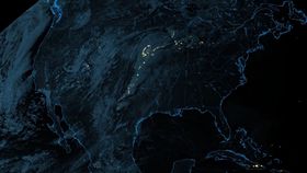


We’ve seen lightning from space before, but you’ve probably never seen it like this.
An instrument on a new weather satellite has captured a stunning view of lightning over North America. The time-lapse video below shows about an hour of activity, as a string of storms moves across the country.
It was taken by the Geostationary Lightning Mapper (GLM) on NOAA’s GOES-17 satellite, built by Lockheed Martin. The satellite was launched on March 1, 2018 aboard an Atlas V rocket, and is now in a geostationary orbit 35,000 kilometers (22,000 miles) above the planet.
The instrument will be used to continuously track lightning from space, the first ever to do so. This will provide new real-time data on storms from New Zealand to Canada, useful not only for scientists but for planes too.
“The mapper observes lightning in the Western Hemisphere, giving forecasters an indication of when a storm is forming, intensifying and becoming more dangerous,” NOAA said in a statement. “Rapid increases of lightning are a signal that a storm may strengthen quickly and could produce severe weather.”
Here's another video of a view from the satellite.
This isn’t the first GLM sent to space, with another being on the GOES-16 satellite which is situated above the East Coast of North America. But GOES-17 will be the first to track lightning over the West Coast and the Pacific.
The team received their “first light” from the GLM on GOES-17 back in April, staying up well into the night to watch the moment the data was received back on Earth. You can check out their reaction to the moment in the video below.
As Popular Science notes, GOES-17 is currently in a testing position centered over the Western Hemisphere. Later this year it’ll be moved, so that it’s positioned over the West Coast of North America, giving it its full view to track storms over the Pacific.
In long-lived storms, lightning can travel hundreds of miles before it hits the ground. So GLM will be able to show where the risk of lightning strikes are greatest, which could be vital in dry areas in the western US that are at risk of wildfires.
“When combined with radar and other satellite data, GLM data will help forecasters anticipate severe weather and issue flood and flash flood warnings sooner,” said NOAA. “Data from GLM will serve an essential role in helping to keep American lives and property safe.”