

The latest explosive eruption at Guatemala’s Volcan de Fuego (“fire volcano”) lasted less than a day, but it’s already one of the deadliest of the 21st century. Although originally miscommunicated as streams or rivers of lava, the explosive activity instead generated profuse pyroclastic flows, which rushed through villages and valleys, destroying pretty much everything in their way.
As first reported by Adam Voiland of NASA’s Earth Observatory, the images of the eruption from space are both stunning and humbling.
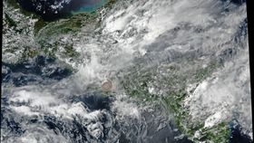
The first – pictured via the Visible Infrared Imaging Radiometer Suite (VIRS) on the Suomi NPP weather satellite – depicts the eruption column at 1pm local time on June 3. Here, you can see the brownish ash plume just after it pierced through a plateau of clouds.
Ultimately, it reached a height of 10 to 15 kilometers (6 to 9 miles), the lower end of which is about the cruising altitude of a typical passenger jet. Can you see it?

Can't see it? How about now:

The collapse of part of this plume, as well as potentially the “boiling over” of eruptive material from the source vent, triggered the pyroclastic flows that led to so much horrific destruction downslope.
Here, we have a gif – taken by the National Oceanic and Atmospheric Administration’s (NOAA) GOES-East satellite – showing the most explosive segment of the eruption sequence. A brownish plume of ash rises through the cloud layer, before disappearing into the prevailing winds at that altitude.
A Twitter chat between Voiland and meteorologist Kathryn Prociv suggests there could even be gravity waves present in the GOES clip. These ripples in the clouds form when a source of buoyancy pushes air up, and gravity pulls it back down again – not unsurprising considering that such an explosive eruption ended up disrupting the atmosphere above it.
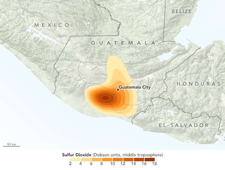
According to meteorologist Wes Callison, the plume of ash spread out to a distance of 97 kilometers (60 miles). Simon Carn, a volcanologist from Michigan Technological University, shared another image of the Suomi NPP satellite, describing how the remnants of the eruption cloud and its sulfur dioxide emissions can be seen drifting out over Central America and the Caribbean Sea.
The official death toll is currently sitting at around 69, according to the authorities, but there’s a chance it could rise as search efforts continue. At the moment, thousands of people are being housed in makeshift shelters, awaiting their uncertain future.
Earther posits that the past activity of the volcano, which doesn’t normally feature explosivity of this magnitude, may have caught the local people off-guard. At the same time, volcanologists have suggested on social media that footage of locals filming oncoming pyroclastic flows hints at an educational deficit in the area – at least when it comes to volcanic hazards.