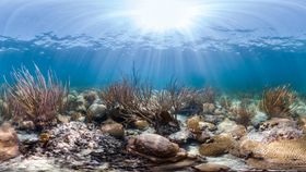


It's not the usual kind of buried treasure, but newly discovered 18th-century British Admiralty charts of Florida have provided marine scientists with a unique sort of gold. The maps show just how rich the coral once was off Florida's coast. It appears human activity has been damaging reefs there for a very long time, and nobody knew until now.
The rest of this article is behind a paywall. Please sign in or subscribe to access the full content.The maps are surprisingly detailed. A century after they were made, cartographers started mapping the depth of the waters into which they might sail and nothing else. However, their predecessors went to considerable efforts to also describe marine features like coral. Dr Loren McClenachan of Colby College, Maine, dug out the charts and came up with the bright idea of using them to compare today's coral cover with that of the time of the American War of Independence.
"We found near the shore, entire sections of reef are gone, but in contrast, most coral mapped further from land is still coral reef habitat today," McClenachan said in a statement.
Co-author Professor John Pandolfi of the University of Queensland noted that the work, reported in Science Advances, reveals coral declines are greater than ever suspected. "We found that reef used to exist in areas that today are not even classified as reef habitat anymore," he said.
"We tend to focus on known areas where we can measure change. That makes sense. Why would you look for coral where you never knew it was?" added McClenachan. However, this distorts estimates of coral loss.
Pandolfi told IFLScience that as soon as coral dies it starts to erode. Many of the reefs marked on the map are thought to have been destroyed either by construction work in the early 20th century or by the release of sediment when parts of the Everglades were drained. About a century after losing their last coral, the reefs eroded so much that no one knew they'd ever been there.
Having proven the usefulness of the charts as a measure of regional coral decline, Pandolfi hopes that similar studies will be conducted in other areas where records from the appropriate era can be found. He thinks such maps may also reveal information about sea level rise, but this might not actually be very useful. “We already have nice proxies for sea levels in recent centuries from corals and oysters,” he told IFLScience.