

Oh NASA – you spoil us with your delightful, eye-opening photography. Whether you’re pointing your camera out into the cosmos or down towards our pale blue dot, you’ve always got something rather glorious and slightly geeky to show off.
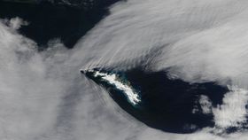
This time, the agency snapped a photograph of some dramatically parting clouds between the South Georgia and the South Sandwich Islands. A British overseas territory in the Atlantic Ocean, they’re extremely remote and prone to volcanic eruptions and penguin occupation.
But what is the ripple-like witchcraft happening with the clouds, we hear you ask. Well that, dear readers, is due to a fluid dynamics phenomenon known as a “gravity wave”.
Say you’ve got two fluids, two materials that are mobile and compressible, but with different densities. When the two are in a state of equilibrium of balance, they are motionless.
However, when the system is upset – perhaps due to the chaotic nature of how they are moving against each other or due to local density changes – things fall out of equilibrium and inertial forces attempt to restore the balance.
The motion of the wind on the sea, for example, creates surface waves. This, of course, is the image we normally associate with the word “wave”, which is the sloshing about of the water as the air above tries to reach equilibrium. Water isn’t the only place you get waves, though – any fluid can feature them.
In the case of NASA’s latest satellite image, we have the cloud and the air around it as the two fluids. As the air flowed over the islands, it bunches up and stretches out, causing crests and troughs in the local atmosphere.
As the clouds were present, these crests and troughs became visible to NASA’s satellite peering down from above. So there you have it!