

The much-hyped LiDAR scanning is seemingly revolutionizing the way archaeologists discover long-lost ancient cities. Just recently, researchers revealed they had used this high-tech imaging technique to find a sprawling ancient Mayan city hiding in the thick jungles of northern Guatemala.
Now, the same imaging technique has been used to rediscover the ancient metropolis of Angamuco in western Mexico after laying in obscurity for centuries.
As first reported by The Guardian, Christopher Fisher of Colorado State University presented the findings at the 2018 AAAS Annual Meeting in Texas today, February 16.
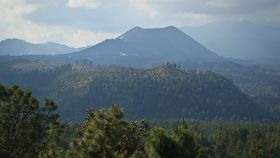
The city was built by the Purépecha empire around 1,100 years ago in the current-day Mexican state of Michoacán in the shadows of the Parícutin volcano. The work details the discovery of large urban centers alongside evidence of grand gardens and monument-like structures, and perhaps even pyramids. The settlement is so large and advanced, it appears to be miles ahead of the social complexities found elsewhere in the region at the time it was built.
The city’s remains are now buried beneath the earth or hidden beneath the forest, but the aerial LiDAR survey revealed it might have once sprawled for at least 26 square kilometers (10 square miles).
“That is a huge area with a lot of people and a lot of architectural foundations that are represented," Fisher told The Guardian before he gave his presentation on the research. "If you do the maths, all of a sudden you are talking about 40,000 building foundations up there, which is [about] the same number of building foundations that are on the island of Manhattan.”
A separate airborne LiDAR survey by the same team also revealed a town in a remote valley in the Mosquitia tropical wilderness of Honduras. Although considerably smaller than Angamuco, it contained an equally impressive array of structures, plazas, and monuments.
LiDAR, short for “Light detection and ranging,” is a remote sensing technique that uses laser pulses to generate precise three-dimensional data about the shape of the Earth’s surface. One of its main skills is the ability to provide a vast overview of the ground, picking out large underlying features that go easily unnoticed with the naked eye.
Now that LiDAR has discovered the overview of the city, archaeologists need to put boots on the ground to discover what this city and culture was really like.