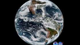


Despite ongoing malfunctions, NOAA’s GOES-17 weather satellite is already sending back stunningly high-definition images of Earth just 30 days after its launch.
Currently observing the planet from a fixed orbit at 35,900 kilometers (22,300 miles) above the equator, GOES-17’s mission is to continually monitor atmospheric, oceanic, and environmental phenomena occurring in the planet’s Western Hemisphere using its Advanced Baseline Imager (ABI) instrument, and to measure the Sun and space environment with onboard ultraviolet and X-ray imagers, as well as atomic particle and magnetic field detectors.
The ABI functions by snapping pictures with 16 separate bands of light: two visible, four near-infrared, and 10 infrared. Analyzing reflected light in each of these wavelengths provides important information about dust, haze, smoke, water vapor, fog, winds, and vegetation.
However, 13 of the ABI’s channels are currently offline because the ABI’s onboard cooling system failed to turn on properly after the satellite settled into orbit. According to a May 23 official media call, the instrument’s extremely sensitive technology only works if it is kept at a frigid -213°C (-351°F).
As of now, the team is trying to restore the cooling system by “pursuing multiple courses of possible corrective actions”. They note that the satellite is still in its post-launch checkout and testing phase, which is expected to continue into late 2018.
But thankfully for all of us who don't work in the field of monitoring weather and just want to look at pretty pictures, the three working channels gather light in the two visible (blue and red) bands and one near-infrared band that's excellent for studying vegetation.
The images released yesterday were created by combining light data collected on May 20 from all three bands into one “GeoColor” view. The result mimics the colors we would see with our naked eye yet provides a sharpness far beyond the abilities of our cornea and retina.
Fusing many such images taken throughout the day allowed the team to create the short but spectacular sunset time-lapse video, which you can see below.
The satellite might need to work out a few issues, but overall, not bad for its first month on the job.