

UPDATE: 2014 MU69 is now officially named Arrokoth
The rest of this article is behind a paywall. Please sign in or subscribe to access the full content.A few weeks after its historic flyby, NASA’s New Horizons has been slowly but surely sending data back to Earth. The mission team has now released the best image yet of Ultima Thule, the furthest world humanity has ever explored.
The new image was snapped just seven minutes before closest approach at a distance of about 6,700 kilometers (4,200 miles). The closest approach was at almost half that distance when the spacecraft was moving at 14 kilometers per second (32,000 miles per hour).
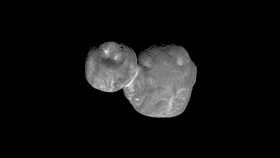
The new image has a resolution of 135 meters (440 feet) per pixel and it finally shows more intricate details of the two-lobe object. Ultima Thule, technically known as object 2014 MU69, has been revealed to have a variety of light and dark patches, which are currently of unknown origin. It is particularly exciting just how bright the “neck” joining the two lobes looks.
The image also shows small depressions on the terminator, the day/night boundary, each roughly 700 meters (0.4 miles) across. The smaller lobe has a depression 10 times larger. The jury is still out on whether these “dimples” are actual craters or depressions created by other geological processes.
"This new image is starting to reveal differences in the geologic character of the two lobes of Ultima Thule, and is presenting us with new mysteries as well," principal investigator Alan Stern, from the Southwest Research Institute in Boulder, Colorado, said in a statement.
"Over the next month, there will be better color and better resolution images that we hope will help unravel the many mysteries of Ultima Thule."
Ultima Thule is located in the Kuiper Belt, the region of the Solar System beyond the orbit of Neptune, which extends out up to 18 billion kilometers (11 billion miles) from the Sun. Ultima Thule itself is 6.49 billion kilometers (4 billion miles) from the Sun – as far from Pluto (New Horizons' previous target) as Saturn is from Earth. The object gets its nickname from Thule, the ancient Greek and Latin name for what was then thought to be the most northerly region in the world, identified to be Iceland, Norway or the Shetland Isles.
On its flyby, New Horizons collected information about this distant world's morphology, geology, and composition. The huge amount of data gathered is slowly being transmitted back to Earth at the snail speed of 500 bits per second. The full dataset will be downloaded by September 2020.