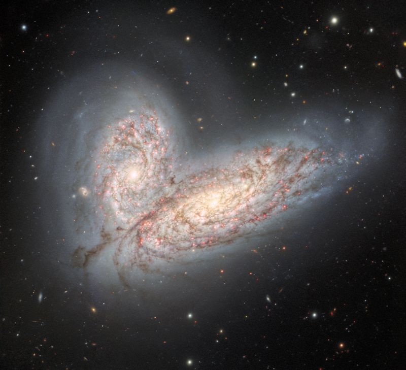


The European Union’s newest Earth observation satellite, Sentinel-1b, has begun returning its first visually striking radar imagery. The focus this time was on a 250-kilometer (155 miles) stretch of the Arctic, including some of the Svalbard island group, a Norwegian territory that contains the “Doomsday” seed vault. Nordaustlandet's Austfonna ice cap can also be seen, near the top left of the full image below.
Sentinel-1b is one of several satellites designed by the European Space Agency (ESA) as part of a global environmental monitoring program called Copernicus. There are six groups of satellites: Sentinel-1a and 1b are polar-orbiting, all-weather, day-and-night radar imaging missions designed to look at how the land, ice, and marine environments all over the planet change over time.
The other five groups of Sentinels look at changes in the atmosphere, soil and vegetation cover, water saturation from the continental cores to the coastal regions, and sea level. All in all, they will provide scientists all across the world with up-to-date data on environments, ecosystems and climates from across Earth. The effects of man-made climate change will also be more precisely quantified using data from Copernicus.

Austfonna is the large ice cap seen towards the top left of this image. The image has been colored for presentation purposes. Copernicus/ESA
Five terabits of data will be produced by Sentinels-1a and 1b every single day, all of which will be completely open access for anyone to peruse. With their orbits offset from each other by 180 degrees, the pair will be able to map the entire surface of Earth in just six days.
In fact, their polar orbits will provide researchers back on the ground with real-time monitoring of regions that may have suddenly experienced a natural disaster, including storms, tsunamis, landslides, volcanic eruptions, earthquakes, and hurricanes. This data can then be sent to emergency services to aid in their relief efforts.
Sentinel-1a was launched back in 2014, with its partner satellite sent into orbit just this Monday via a Soyuz rocket. After engineers checked that it had reached a stable orbit, its solar panels opened successfully, and its instrumentation was all entirely functional, they commanded it to take its very first snaps from hundreds of kilometers above us. In the next few weeks, it will be maneuvered to its final polar orbit, 700 kilometers (435 miles) high.
The Copernicus program, indubitably the world’s largest single Earth observation initiative, is entirely funded by the European Union – a wonderful example of what can be accomplished when nations work together in the name of scientific progress. Considering this huge endeavor is really only possible with everyone in this supranational organization pulling their weight, it would be a great shame if it were ever to break-up.

An artist’s impression of how a radar satellite like Sentinel-1b can peer through the clouds to map Earth’s surface. ESA