

Inhale. Exhale.
With every breath you take your lungs are filling with air that is made up of minuscule particles from the environment around you, both natural and manmade, and a visualization of satellite data compiled by NASA shows just what type of floaties you’re breathing in.
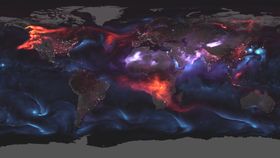
To depict this, NASA's modeling system, Goddard Earth Observing System Forward Processing (GOES FP), used mathematical equations to create data on what was happening in the atmosphere on August 23.
“On that day, huge plumes of smoke drifted over North America and Africa, three different tropical cyclones churned in the Pacific Ocean, and large clouds of dust blew over deserts in Africa and Asia," explained NASA in a statement.
Giant swirls of sea salt aerosol (SSA) are visible in blue, black carbon particles emitted largely by fires, as well as vehicles and factory emissions, are shown in red, and dust is shown in purple. All of these elements are laid over light data collected by the Visible Infrared Imaging Radiometer Suite (VIRS) on Suomi NPP.
What we’re seeing is a pretty good graphical element of the major environmental events sweeping international headlines over the last few weeks. Hurricane Lane is seen chugging toward Hawaii, bringing with it dozens of inches of rainfall, churning up sea salt aerosol in its wake.

Over North America, wildfire smoke emitted by the nearly 2 million acres that are currently burning in the US alone is depicted as pushing smoke particles across the western side of the continent to the east jet stream.
Head 6,000 miles east and the map shows a dust storm picking up sand and other fine grain particles over the Saharan Desert. Pop down south where plumes of heat from intentional agricultural burning in southern Africa are visible.
Moving northeast Typhoons Soulik and Cimarron are shown heading towards South Korea and Japan with high winds and heavy rains picked up in their path.

From smoke particles to water droplets, the things we breathe in on a daily basis are known collectively as “aerosols”. These tiny particles have a big impact and are found in the air over oceans, mountains, forests, deserts, and every ecosystem on Earth. Ranging in size, they drift in the Earth’s atmosphere to the stratosphere. According to NASA, around 90 percent of aerosols have natural origins, such as volcanoes ejecting plumes of ash or microalgae on the surface of the ocean spoofing off calcium carbonate. The other 10 percent are man-made and come from things like fossil fuel combustion, agricultural burning, deforestation, and even cigarettes and fireplaces.
These graphics serve as a good reminder that no matter what pocket of the world you live in, we’re all interconnected to one another – even if it’s just by a bit of wind.